The stifling math curriculum seemed to buzz on and on and blue sky visible through the classroom window was too darned tempting.
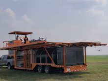
So classes from five Manitoba rural school divisions took a day off regular school work June 12.
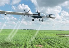
More than 50 high school students from five rural Manitoba school divisions learned to pilot agricultural data-gathering drones.
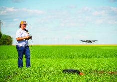
They also logged soil data, vegetative data and images taken from the drone, complete with GPS co-ordinates. Under the direction of licensed instructors, the newbie unmanned aerial vehicle (UAV) pilots spent six hours in the Portage la Prairie sunshine learning about drones from the basics to the thrill of solo flight.
The drone school was organized by Matt Johnson, vice-president of Volatus Unmanned Services (Volatus Aerospace) which provides UAV training in Manitoba. Johnson said the one-day school exposes high school students to academic research activities using drones.
A focus is to teach students how to safely and legally operate drones and collect data. Students rotated through six learning stations, including three flight platforms. The curriculum was conducted in three phases.
Phase 1 — Students learn ground theory, including how to conduct agronomic activities such as soil sampling, leaf-chlorophyll analysis and root analysis.
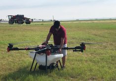
Phase 2 — Students learn to pilot micro-drones weighing less than 250 grams and small remotely piloted aircraft up to about one kilogram.
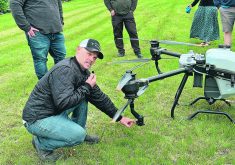
Phase 3 — Students learn how larger RPAS (Remotely Piloted Aircraft System) platforms such as the DJI Matrice 300 are used to collect aerial data during mapping missions.
The instructional mapping activity was part of a data collection field day for an ongoing project of the Science Experiential Aerial Research (SEAR) Program based in Portage la Prairie.
Drone measures N — one station featuring real-life agronomic activity was focused on using drones to measure chlorophyl in leaves. Instructor Gary Coukell said few of the high school students who visited his tent knew in advance that measuring chlorophyl in leaves is a good indicator of nitrogen levels in the plant.

“We use an atLEAF sensor. It has its own light source so sunlight doesn’t alter the readings very much. The leaf slides into a small slit so there’s only a small amount of ambient light in there with the leaf,” said Coukell.
He added that it’s different from the GreenSeeker because of the independent light source. Rather than take a reflective reading from the whole standing crop, the atLEAF meter exposes a small portion of leaf to the abundant controlled light source inside and measures how much light was not captured by chlorophyll in the photosynthetic process. It measures greenness.
“The traditional way to measure nitrogen content was to take leaf samples and send them to a plant tissue analysis lab. It might take days or even a week before you get the results. A hand-held sensor is something growers and researchers can use in the field to document colour and nitrogen levels. You get results immediately.
“Students are using the equipment we have here today to take their own measurements of chlorophyl in leaves. They’ll be able to turn that data into available nitrogen data. This atLEAF data can then be used in drone imagery.
“From reading leaves, the next higher level of technology we employ is the drone. You can fly a drone over a field and take images of every acre. Once you’ve calibrated aerial images to coincide with chlorophyl readings from your hand held sensor, you can determine nitrogen levels in the different zones in your field.
Soil analysis — Kathleen Meagher was in charge of Site One, the soil analysis station. Her assignment was to explain the base soil information an agronomist would typically collect before seed and fertilizer went into the ground.
“The farmer needs to know what nutrients are available and what crops he can plant, based on soil conditions. They need to know about soil moisture, nutrient levels, pH levels, soil classification and soil temperature.
“The students are using the moisture probes and the pH probes just like the ones I’ve been using my whole 20-year career. Once they record this soil data, it can be made available to the drone operator who can collect the dots between soil and aerial image.”
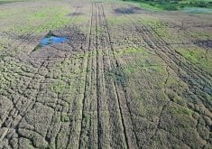
Drone detects root disease — Matt Johnson said the root disease detection exercise uses a standard comparison plot, but with the addition of aerial drone sensing. There’s the target plot that’s been inoculated with root disease and the standard control strip with no disease.
“Students studied root samples from both plots to see root disease first-hand in the leaves, which also shows up in the aerial image. What we’re teaching here is very basic. We show the students how to ground truth what they detect on the aerial images.”
Root disease detection in ag areas is only one part of the SEAR program. Johnson said SEAR is also using their Volatus drone imagery in Winnipeg to detect Dutch elm disease secreted in the thick canopy of the city’s tree-lined neighbourhoods. He can determine tree health by reading the way near infrared (NIR) light reacts with the leaves.
“We’ve been working on the algorithms for two years. We need one more year of data and then we’re ready to launch. It looks very promising. We’re finding plenty of diseased trees with our drones.”
Jody Wielgosh brought a van load of students from Beausejour area where he is principal of the Sunrise School Division. He says,

“We’re on the ground floor of this technology. We’ve seen here today that the students certainly have the aptitude. There’s a lot of enthusiasm to learn the fly a drone and get the basic pilot license,” he said.
“It seems like the sky is the limit in terms of what can be accomplished with further training and employment opportunities. Our school division is in a rural area, so agriculture is a major factor in the families of all these students. I think they see that this drone technology can be a major factor in crop management and increasing yields. In our area, there’s also forestry and hydro and other resource development that can use drone imagery.
“We have a couple of students who already have their basic licence. If they want to continue earning the other credentials, the division will cover their costs.”
Drone student Taylor Collins said, “Drone technology gives us the ability to do things such as checking fields like we did before, but now we do that checking with the drone. Why would you waste time walking out into the field manually if you can check far more acres in less time from the air? It’s all tied to the sensing technology and the algorithms they develop through ground-truthing.”