BRANDON — John Gehrer would likely say there is no single best combinatino of GPS control systems to manage field drainage.
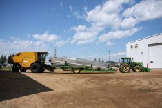
The Niverville, Man., farmer spent last summer comparing drainage control technologies. He also does custom spraying and drainage work, and has been using GPS since 1997. In a recent presentation, he touched on the everyday plus and minus factors of lasers, WAAS (wide area augmentation system), cellular phone networks, RTK (real time kinematic), laptop versus actual screens and individual and networked tall tower base stations.
He said laser systems are not obsolete, despite what GPS sales people might say.
Read Also
Livestock movement scanner looks for proving ground
The Canadian Cattle Identification Agency (CCIA) will test new technology intended to simplify the recording of animal movements, linked to proposed federal livestock traceability regulations.
“I talked to quite a few farmers about this last summer, and a lot of them are still buying lasers for drainage,” he said.
Not everyone has jumped on the high end RTK bandwagon, either, he added.
“The main advantage is that it (laser) gives you more independence and reliability. Plus it’s very accurate,” said Gehrer.
“You can combine GPS and laser to build a very accurate topography map based on elevations from your laser and directional latitude/longitude from a very basic GPS.”
He said distance is the main drawback with the laser. Farmers cannot possibly map two adjacent sections with a single setup.
The laser needs line of sight, so hills also limit the coverage area. With a pure GPS system, the operator simply drives along and the GPS follows the contour of the land.
Gehrer said the laser works best on a quarter section. It’s possible to do an entire section with a single setup, but only if it’s flat and there’s no wind.
The laser tower is susceptible to wind movement because it must be so high. It’s time to shut down when the signal can be seen going up and down on the mast.
“The laser beam has to be at the same height as your mast, usually 10 or 12 feet. Some guys go higher, above the cab, so the mast has a totally round view.
“So then you need a large tripod or an extra truck in the field, which has to remain stationary. That means dragging one more piece of machinery into the field.
“Set-up time is another issue for me. I was custom spraying while I was conducting these comparisons last summer. I always want zero set-up time so I don’t waste valuable spraying time.”
WAAS versus high-end RTK is an ongoing debate. WAAS is still subscription-free and works well for steering in southeastern Manitoba, where Gehrer farms.
He said one-foot accuracy is acceptable to him for guiding his air seeder and sprayer.
“In 14 years of using WAAS, I’ve only had to stop work once because of a lost signal. It’s extremely reliable compared to other systems.
“I’ve found that RTK goes out a lot. You get a fuzzy signal unless all the components are working together. The more factors that must work together, the more chance you have of things going wrong. Everything has to be just right.
“I think if I was seeding corn with RTK, I would definitely not want to lose my signal. I would want a tower in my field so I knew I could finish the job.”
Tall tower base stations are used independently and in networks. For the comparison, Gehrer tried a single base station on top of a Harvestore.
He said zero set-up time is one big advantage, provided the operator turns the system on as soon as he gets in the cab, giving it five or ten minutes to warm up and dial in its accuracy.
Gehrer, who does custom work within a 50 kilometre radius, said the single base station on a tall tower does not fit his custom business.
“You can go anywhere that tower serves, but that limits you to a five mile (eight km) radius. This is good for a farmer who has a nice tall structure like a grain leg or a Harvestore, and has all his fields within that five mile radius.”
Gehrer said the high base station provides good, ditching-quality RTK signals within that circle, as long as there’s a line of sight from the machine to the tower.
“Beyond the five miles, you have to ask yourself what degree of accuracy you really need. Can you get by with sprayer accuracy or do you need high quality RTK for drainage?”
The single base station mounted on a tall tower is typically owned by the farmer who owns the land.
The other arrangement is a network of many towers owned and managed by a local ag business such as a fertilizer or equipment dealer.
Each producer buys a subscription and receives a code for each tower. He punches in the code for the tower nearest to the field in which he’s working.
If the towers are located close enough, the network system can eliminate the problem of diminishing signal beyond the eight km circle. That advantage is lost if the tower network is not tight enough.
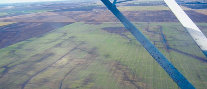
“When I was working with the tower network, I found that five miles beyond the chosen tower, the accuracy was not good enough for ditching. You need 100 percent elevation accuracy for ditching. Whatever system you use, the elevation accuracy always drops off more quickly than the left-right steering accuracy.”
Cellphone networks are common in areas served by a good pattern of towers. The principle is the same as the tall tower base station scheme, but the cellphone does not require line of sight.
“The other difference is the cell network accesses a number of towers at the same time, which gives it a lot better accuracy. And there’s no need for a farmer to be as close to a tower as he would need to be with the base station on a tall tower.
“I think for my ditching work, the cellular network should be OK.”
Gehrer said it’s easy for farmers to test the viability of the cell network for their own farm. Simply try to make a cellphone call from each field. If there’s no cell signal, then they know for sure the cellular network won’t work for steering guidance.
He said it not only depends on how close they are to cell towers but also how smoothly the cell phone system is running on any particular day.
“One big advantage is that when the cellular network goes down, it comes back by itself. If I lose signal for a few minutes while I’m ditching, it doesn’t matter because I can still work on the sides of the ditches, so I’m not wasting time.”
Farmers also have to decide between laptop or actual screen when making major upgrades and changes.
“The actual screen comes with the original software. There’s no choice. But the screen is pretty pricey,” Gehrer said.
“If you already have a laptop, you can buy a good drainage program somebody has written for your laptop. There are many small companies in that business today. I have a program on my laptop for elevation and mapping. I was surprised at how good it was.”
Gehrer said the question is how much support and how many upgrades will farmers get on a continued basis from a small company, and how much subscription money do they have to pay.
“What if he sells you a really good topography program, but after two years he closes up because he’s not making enough money? You’re left stranded. But the drainage software from someone like John Deere or Case won’t go away. It will only get better. They’ll stand behind it.”
Gehrer said farmers who don’t want to waste time trying to make a new program work should buy the factory program that matches the colour of their tractor.
“If you’re the kind of farmer who likes to dabble and explore and play around with things, then I’d say try the aftermarket software. The aftermarket drainage programs work quite well and they cost less money.
“As for the $30,000 high end systems, I can’t see the payback. I have about $16,000 invested and that gives me full ditching-caliber RTK. And I pay an annual subscription fee.”
For more information, contact Gehrer at 866-860-6086 or johngehrer@yahoo.ca.