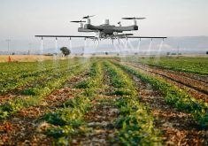
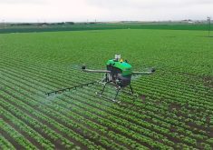
Drone chopper | Battery-powered machine scouts fields slowly, precisely and costs half as much
If the $75,000 US price tag on a gas-powered field-scouting AutoCopter G15 is too expensive, the company has just released a battery-powered version called SuperScout for about half the price.
The original AutoCopter G15, which was introduced three years ago, has a six-foot rotor span and is powered by a small two-cycle en-gine. It has GPS referenced autopilot and can fly a precise programmed pattern over a field.
It carries high definition video, a multi-spectral camera for normalized difference vegetation index imaging and software allowing NDVI maps to be produced in the field within minutes of landing.
Read Also
Growing garlic by the thousands in Manitoba
Grower holds a planting party day every fall as a crowd gathers to help put 28,000 plants, and sometimes more, into theground
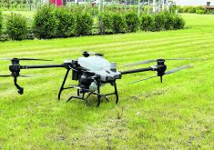
The price prevented more crop consultants from buying the G15, so enter the new world of high efficiency batteries. SuperScout is powered by a re-chargeable battery, but other than that, it has all the capabilities of its big brother.
The $35,000 price includes three batteries to be used in rotation. A heated battery straight out of the SuperScout must be allowed to cool down to the ambient temperature before going back on the charger. With three in rotation, there’s always one cool battery ready to go on the charger, says AutoCopter president Donald Effren.
“Most of these (battery powered unmanned areal vehicles) will fly on average 10 to 20 minutes, sometimes more, sometimes less, because of many factors,” he said. “I would say our flight time is right there with the others in this category.”
The gyro software controls six independent electric motors, each spinning its own rotor. The precisely controlled rotors create a stable platform for high resolution images of the field. The air frame consists of aluminum and carbon fibre.
SuperScout has three cameras with streaming video to ground control, full-colour geo-referenced images and multi-spectral NDVI.
The ground control station includes a laptop and video glasses so the operator can monitor the system in sunny conditions.
Effren said flight plans can be programmed in advance. The autopilot software looks after takeoff, landing and flying and can reference 200 waypoints.
After the plan is flown, it’s saved to the lap top and can be flown again the following week or even years later. The package also includes AutoCopter’s software for processing data immediately in the field.
“Our software lets you download your NDVI images immediately after landing. We can process 100 images in 100 seconds. You can write a prescription map right there on the spot if you need to.”
He said aerial images can identify numerous field situations that merit immediate attention requiring a prescription map, including applications of herbicides, fungicides, insecticides and top dressing nitrogen.
The autopilot can replicate the same flight pattern so the operator can assess how effective a treatment may have been.
Effren said the autopilot landing is gentle enough to ensure the cameras are not damaged.
“Cameras used in this kind of work are delicate and expensive. You don’t want to damage them,” he said.
“Precision farming requires precise accurate aerial photos. Your platform has to be as stable as possible. That’s the only reason for having a helicopter up there in the first place. To capture data. Not to take pretty pictures.”
Effren said some people still don’t grasp the value of geo-referenced aerial photography as a significant agronomic tool. He relates an incident from a recent trade show.
“The crop consultant actually told us, ‘I want a pretty picture.’ It was at that moment we realized something was missing from the discussion,” he said. “Taking a picture of the field is cute but it doesn’t help save money or increase yields for the grower. The future benefit is to fly the same section of the field again and see the changes.”
For more information, contact Don Effren at 704-835-0314 or visit www.autocopter.net.