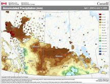

Farmers in central and northern Alberta should brace for drought this summer, according to AccuWeather.
“We think it’s going to be a very warm summer,” said Canadian weather expert Brett Anderson.
It is also going to be a dry summer. June will have near normal precipitation but July and August will turn dry as a high pressure system suppresses storm activity across the prairie region.
Anderson said it will be particularly hot and parched in a wide swath stretching from northwestern Alberta to southeastern Saskatchewan.
Read Also

Farming Smarter receives financial boost from Alberta government for potato research
Farming Smarter near Lethbridge got a boost to its research equipment, thanks to the Alberta government’s increase in funding for research associations.
“Northern and central Alberta really sticks out like a sore thumb in terms of dryness,” he said.
He is not as concerned about the rest of the prairie region.
“I don’t think we’re going into a drought in Saskatchewan. I think we have enough moisture in the ground,” said Anderson.
Manitoba will receive thunderstorms from time to time throughout the summer months and is not expected to be as warm as the other prairie provinces.
“The odds of seeing any widespread drought in that (province) are probably 30 percent or less,” he said.
Anderson said his forecast has nothing to do with a weak El Nino forming. He doesn’t expect that to have any impact on weather patterns until fall or winter.
It is more about the disappearance of a blob of warm water in the Pacific Ocean off the west coast of North America. The blob sent moisture across Western Canada the last couple of years.
In its absence, a high pressure system will form over the prairie region.
“That acts like a big bubble,” said Anderson.
“Any fronts that come in from the north and west, they kind of move around that bubble and the dryness builds across the region.”
The good news is the bubble will reduce the threat of severe thunderstorms because there isn’t the wind energy aloft that is transferred down to the ground.
It also reduces the threat of hail because the persistent high pressure system results in warmer temperatures aloft and the less likelihood of hail formation.
Contact sean.pratt@producer.com