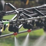
BRANDON – The variable rate principle isn’t just for fertilizer. It can also be applied to fungicides.
High risk areas of a field receive the full rate while low risk areas receive half the rate. No-risk areas aren’t sprayed at all, which means there’s no crop trampling and no wasted fungicide.
Agritrend adviser Terry Aberhart said farmers shouldn’t assume they can use their elevation maps to chart disease risk, based on the idea that low lying areas are more prone to disease,
“It’s not necessarily the topography. Disease risk is more related to crop density,” Aberhart said.
Read Also

VIDEO: Green Lightning and Nytro Ag win sustainability innovation award
Nytro Ag Corp and Green Lightning recieved an innovation award at Ag in Motion 2025 for the Green Lightning Nitrogen Machine, which converts atmospheric nitrogen into a plant-usable form.
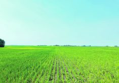
“You need a good, high quality NDVI photo taken a week or two before the spray date. NDVI gives us the density of the crop canopy. We base our fungicide prescription map on that density.”
Aberhart said it’s natural to think the low spots will harbour plant diseases, but in a wet year those low spots are often flooded, so the dense vegetation is on higher ground.
The following year might be dry, so the situation is reversed, with the dense vegetation in the low areas. In other years, mid slopes might have the dense vegetation and the high risk of plant disease.
“That’s why you always need a fresh, high resolution image for variable rate fungicide.”
Aberhart said the timeliness of satellite images is improving, but they seldom have the quality he needs for a precise fungicide prescription map. Although he has found a few satellite images with one metre pixels, most satellite images are still 15 to 30 metres.
Aberhart said that if a fungicide prescription map is going to make money for a client, it needs to be one metre quality so he can accurately measure crop density. He said five metre pixels work, but not as well.
“Here’s an example. We programmed the sprayer according to a 30 metre sat photo. There’s a big drain through the field, about 50 feet wide. On one pass through the drain, it switches the boom on and off. Next time it shuts the boom off 100 feet after you’re out of the drain and then switches it back on somewhere else in the field where we know it should be off.”
Aberhart said the timing of aerial photography can make a big difference when making decisions in canola fields.
Green Seeker, which has run its technology over canola fields at different growth stages and then correlated its summer data to yield at harvest time, has found that it’s easiest to predict disease risk when aerial photographs are made while the crop is in the rosette and bolting stage.
Aberhart said the research shows there might be a place for Green Seeker technology in more roles than just on-the-go in-crop nitrogen.
“In the future, if we want more control over the timing and quality of the images we use, I think we’ll move toward some kind of advanced crop cam or military drone.
“I can see big farms flying their own drones. Or perhaps a military quality drone can fly and shoot a 20 mile radius once a week, and send images back to the clients.”
For more information, contact Terry Aberhart at taberhart@agritrend.com.