Instead of poking along a grid road with heads hanging out their truck windows, nosy neighbors can now check out your crops from outer space.
“You can pick out a lot of farming practices you know, (like) whether your neighbors have been draining their swamps or something like that,” said Jim Finnigan.
Finnigan is president of Digital Environmental Management Inc., a Saskatoon company that sells images produced by all of the commercial satellites in orbit.
“At today’s resolution you can photograph your wheat being loaded, count the number of grain cars really available, or find out what is being planted in another corner of the province,” says a company news release.
Read Also

Organic farmers urged to make better use of trade deals
Organic growers should be singing CUSMA’s praises, according to the Canadian Chamber of Commerce.
Finnigan said the most anticipated data is from the Ikonos satellite, which can provide discernable images of objects as small as one metre across.
The company is focusing on environmental tasks like helping oil and gas companies avoid sensitive areas and allowing forestry companies to monitor the health of forests. But Finnigan can also see plenty of applications for agriculture.
“It’s kind of amazing, but nobody really knows how big their farm is. You might actually be surprised that you’ve been paying taxes on something that’s a little bit smaller.”
Some of the uses he proposes verge on spying — like monitoring the farm practices of your neighbor or attempting to find out how genetically modified canola ended up in your field.
“I can tell you where all the canola is located within a 500 kilometre radius just with one satellite image.”
Finnigan admits this kind of espionage makes some people apprehensive, and there should be laws and regulations governing it, but he believes the type of activity he is proposing is harmless.
“I think there are privacy concerns, but farming is not really something you can do in secrecy. We’re not seeing people sunbathing in the backyard or counting their trucks to see whether they’re on vacation or not.”
Digital Environmental doesn’t have any farmer customers yet, but the company has been working with the Saskatchewan Crop Insurance Corp.
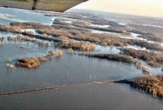
It has photographed hail and flood damage from outer space for the government insurer using a satellite that provides radar images well suited to such tasks because it can photograph through clouds. It can pick up flax bales sitting in a swamp.
The company was able to get a radar image of the Vanguard area four days after a major flood ravaged the region. It also had a preflood image for comparison.
“The town was a completely different color on radar so it was still pretty wet there when the satellite went overhead,” said Finnigan.
Lisa Schick, GIS co-ordinator with the crop insurance corporation, said it is just starting to experiment with satellite imagery because the price has dropped and image resolution has risen in recent years. A photograph of a 183 sq. km area sells for $900.
Schick said the insurance corporation is going to compare the satellite images of flood- and hail-damaged regions with what adjusters find and see if there is a strong correlation between the two pieces of data.
If there is a connection, the satellite images could be used to help adjusters save time by targeting areas for investigation.
“Maybe we could do a little more adjusting right in the office before we sent out adjusters.”