A modelling framework using remote sensing environmental data can predict gully erosion susceptibility more accurately
Soil erosion is a constant challenge for many farmers and threatens productivity, yield and income. In addition, soil quality comes under increasing threat, causing pollutants to seep into the ground and enter streams, contaminating aquatic systems.
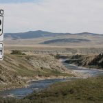
One of the most severe forms of erosion is gullies. They might appear to be innocuous dips in a crop field’s profile at the outset, but they can develop into large channels that carve their way across the land, making their management difficult.
Researchers at the University of Illinois developed a modelling framework using remote sensing environmental data to predict gully erosion susceptibility more accurately.
Read Also

Using artificial intelligence in agriculture starts with the right data
Good data is critical as the agriculture sector increasingly adopts new AI technology to drive efficiency, sustainability and trust across all levels of the value chain.
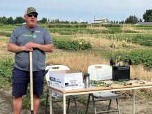
“The research on the impacts of gully erosion was initiated due to a growing concern over the detrimental effects of gully erosion on the environment, infrastructure and local communities,” said Jorge Guzman, research assistant professor in the department of agricultural and biological engineering. “Gullies can lead to the loss of productive land, damage to roads and buildings and increased sedimentation in waterways. Furthermore, sediments from gully erosion can transport contaminants such as pesticides and metals from agricultural land to adjacent water bodies and impact water quality and aquatic ecosystems. Gully erosion is difficult to control once it occurs (but) predicting susceptible areas can help direct resources more effectively.”
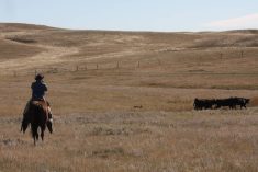
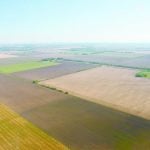
The researchers conducted their study in Illinois’ Jefferson County, where 59 percent of land use is agriculture, mostly in corn and soybeans. The study area encompassed 1,512 sq. kilometres and the area is typical of Midwest row crop production.
Unlike previous studies that required extensive field surveys to record gully erosion locations, Guzman’s team used digital elevation models to find the differences in elevation associated with gully erosion and satellite imagery to validate gully presence.
He said they explored various environmental factors to identify the significant contributing elements, including farmer activity, climate, rainfall, temperatures, vegetation development, land topography and other variables.
“We used the maximum entropy model, or MaxEnt, to predict areas with a high probability of gully erosion,” said Jeongho Han, doctoral student team member in ABE and lead author of the paper. “Typically, researchers have focused on static variables like soil, elevation and slope. But we added temporal variables like precipitation and vegetation because erosion is highly affected by crop growth, temperature and rainfall intensity.”
“While most existing research compares these factors at once, we divided the (environmental) factors into four groups: topography, soil properties, land cover and precipitation,” said Guzman. “Within each group, we compared the factors to quantify the relevance of each one and then a comparative analysis to determine the significant factors in predicting gully erosion susceptibility.”
The approach enabled the simplification of the model while maintaining prediction accuracy. They also devised a strategy to look at time-variable factors such as seasonal vegetation stages using the remotely sensed leaf area index (a ratio of leaf area to ground surface area) and maximum daily precipitation. He said that gully erosion is heavily affected by rain events so incorporating time-variant effects in the model was critical given climate change influences.
“Climate change is expected to exacerbate erosion in some regions due to the increase in temperature or precipitation, leading to increased soil erosion and the formation of rills and gullies on farmland. (Their) severity may depend on various factors such as soil type, slope, vegetation cover, land management practices and the development and implementation of mitigation strategies.”
A total of 5,600 gully erosion sites were examined and the team addressed 28 factors contributing to gully formation.
“In our study area, we found that land use, precisely the types of crops being cultivated, was the most influential factor,” said Guzman. “This finding contrasts with other studies in which slope was found to be the most important factor. Our study also revealed the complexity and challenges of interpreting the effects of various factors on gully erosion. For example, we found that maximum daily precipitation during fall is critical. However, the contribution of this factor varies across a range of precipitation values, increasing as precipitation reaches 80 millimetres per day and then its importance decreasing beyond it. Moreover, information on whether farmers implemented management practices following gully development and what practices were used can be more important in identifying and tracking how the role of each factor has changed over time. Based on our research, we highlight the need for a multidisciplinary approach to better understanding the factors affecting gully erosion to develop programs to control their occurrence or mitigate severity.”
Guzman said that there are several effective land management practices that farmers can implement.
Cover crops can protect soil from erosion by reducing runoff, increasing infiltration, improving soil health and soil structure and reducing soil compaction.
Conservation tillage practices will leave crop residues on the soil surface, reduce soil disturbance and improve soil health while maintaining soil moisture.Terracing, or benches, can help reduce the slope of the land and slow water runoff. The practice would be effective on steeper slopes with the potential for high erosion risks.
Planting grasses along waterways can slow water runoff and promote infiltration. The grass base will help filter sediments and improve water quality.
Proper nutrient management can help maintain soil health while reducing erosion risks. This might include soil testing, precision fertilization and the use of organic materials to improve soil structure and fertility.
“Implementing a combination of these land management practices can help farmers prevent gully development,” he said. “Farmers (can) also work with local conservation organizations and agricultural extension services to identify the most effective practices and programs for their land and soil conditions.”
Guzman said that by knowing where gullies are likely to develop, farmers can start implementing land management practices. The challenge is how to optimize these efforts more effectively.
“Additionally, we are exploring ways to improve prediction accuracies such as through optimization or assembling multiple models’ results,” said Guzman.
He said the goal is to develop more accurate and effective methods for predicting gully erosion.
The research was published in the Journal of Hydrology: Regional Studies.