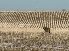
Canadian farmers are getting mixed messages on what kind of a year they
are facing in 2002.
A report from the United States Department of Agriculture forecasting a
second consecutive year of extremely dry weather differs from
precipitation charts published on Environment Canada’s web page.
The Canadian federal government agency is forecasting above normal
precipitation levels for the prairie grain belt this spring and summer.
Part of the reason for the discrepancy is that the Environment Canada
Read Also

Agritechnica Day 2: The future of tractor power, building quicker crop apps and large farms and tech
Agritechnica Day 2: The future of tractor power, building quicker crop apps with Syngenta and large farms and tech
forecasts were issued Dec. 1 and were based on computer models churned
out in November.
Environment Canada meteorologist Mike McDonald said producers should
disregard those old forecasts and wait for the new ones, which will be
published on March 1.
While the new forecasts will be scaled back, McDonald expects them to
be much more optimistic than the USDA’s recent gloom and doom outlook.
The source of his optimism is a slight warming of the Pacific Ocean,
indicating the beginning of a weak El Nino event. That bodes well for
prairie precipitation levels – at least early in the crop year.
“Our feeling here is that it certainly won’t be as bad as last year,
especially with the possibility of an El Nino event, which we didn’t
have last year,” said McDonald.
“So the chances of at least near normal precipitation is a lot better
this year. But as far as above normal precipitation, that seems to be a
little bit far-fetched.”
Researchers thought something was strange with the three, six and
nine-month forecasts when they were generated back in November. They
began to look even more absurd after a few months of what has been an
extremely dry winter.
“It’s usually quite difficult to change the whole philosophy around as
far as going from well below normal precipitation to above normal
precipitation without any real evidence of anything changing with
weather patterns,” said McDonald.
However those earlier forecasts aren’t looking quite so bizarre now. A
few weeks ago weather watchers noticed the first signs of what could be
an El Nino event brewing in the Pacific Ocean.
McDonald said that could trigger spring storms originating in Colorado
that will move northeast into Canada.
“The storm track will be tracking through the southern Prairies in the
spring and it could be fairly active as far as precipitation goes this
year.”
Southern Manitoba and eastern Saskatchewan will be the main
beneficiaries of the spring storms. Areas farther west have less chance
of getting precipitation from the Colorado lows, said McDonald.
If what is happening in the Pacific Ocean develops into a full-fledged
El Nino event, the east and west coasts of Canada can count on lots of
precipitation, especially next winter, but it would have little effect
on the central part of the country aside from generating the spring
storms.
But before farmers go out and spend a lot of money on inputs in
anticipation of a wet spring, they should know that long-term forecasts
are not much more accurate than a flip of the coin, said McDonald.
A case in point is Environment Canada’s December through February
outlook, which called for near to above normal precipitation levels
throughout the prairie region.
Farmers in Manitoba, Saskatchewan and Alberta would have some
uncharitable words about the accuracy of that particular forecast.