Global wheat traders are likely so concentrated on assessing the agricultural implications of Russia’s attack on Ukraine that other issues are on the back burner, but the drought in the western United States might become bigger news in a month or two.
You can’t make solid predictions about a hard red winter wheat crop when it is still in winter dormancy, but if I were a farmer in the U.S. southern Plains, I’d be nervous about drought, which is significantly worse than last year at this time.
Read Also

Trump cuts off trade talks with Canada
UPDATED: October 24, 2025 – 0910 CST – Adds comments from Prime Minister Mark Carney. Reuters — U.S. President Donald…
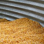
On average, Kansas is by far the largest producer of winter wheat in the United States with 27 percent of the crop. It is mostly hard red wheat.
Oklahoma and Colorado each produce seven percent, Texas six percent and Nebraska four percent.
Kansas topsoil moisture supplies in the week ending Feb. 20 were rated 45 very short, 34 percent short, 20 percent adequate, and one percent surplus, according to the U.S. Department of Agriculture’s National Agricultural Statistics Service. Subsoil moisture supplies rated 39 percent very short, 38 percent short, 23 percent adequate and zero percent surplus.
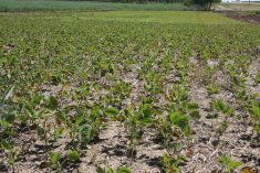
Wheat conditions were rated 35 percent poor to very poor, 39 percent fair and 26 percent good to excellent.
In Oklahoma, 54 percent of topsoil was very short 24 percent short, 20 percent adequate and only two percent surplus. Wheat is 64 percent poor to very poor, 27 percent fair and nine percent good to excellent.
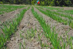
Wheat land in eastern Colorado and northern Texas is similarly very dry.
In January, a USDA survey said that overall winter wheat area for this year was 34.4 million acres, up two percent from last year.
The hard red winter wheat class was at 23.8 million acres, up one percent from last year.
Good spring rain could revive the hard red winter wheat crops, but the chances of that happening don’t look good.
We are still in a La Nina situation and that tends to deliver lower than normal moisture to the southern Plains.
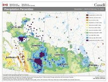
The U.S. National Weather Service Climate Prediction Center web page at www.cpc.ncep.noaa.gov/products/international/ hosts maps of global climate forecast models known as the North American Multi-Model Ensemble (NMME).
Six models are shown: some from the U.S. Weather Service, some from Environment Canada, one from Princeton University and the U.S. National Oceanic and Atmospheric Administration and one from NASA. It also shows a map that is the ensemble mean of all six models.
There are maps for all parts of the world.
The maps for North America show the models forecast drier than normal weather continuing in the U.S. Plains into the summer.
All of them also show warmer than normal temperatures in the region into the summer. Indeed, most of the models show warmer than normal weather for almost all of the continental U.S. for the next six months.
That’s not hopeful for the plains winter wheat, nor the corn and soybeans that get seeded in the area in the spring.
The models also show drier than normal conditions spreading into Iowa’s corn and soybean area in the summer.
On the other hand, most of the models show the eastern corn belt, Illinois, Indiana and Ohio with normal moisture into the summer.
And good news, most of the models forecast average moisture for the Canadian Prairies, as well as North Dakota and Montana, through to June.
However, two of the six models show widespread dry weather in the U.S. creeping up into the Prairies in the June to August period. The rest show normal moisture in that period.
As for temperatures, most of the models show normal to cooler than normal prairie weather into the early spring, but then a transition to warmer than normal for the late spring and summer.
Of course, none of this is written in stone.
Much will depend on how the La Nina winds down.
The U.S. National Weather Service on Feb. 10 forecast a 77 percent chance of the La Nina continuing in the March to May period and a 56 percent chance of it transitioning to neutral in the May to June period.
That backs up the concern about dry weather continuing in the southern Plains and also the transition away from colder than normal weather on the Prairies in the late spring.
Looking at other regions of the world covered by the North American Multi-Model Ensemble forecasts, I see the concern about dry weather continuing in parts of South America for the next couple months, but there are no big issues in Europe, the Black Sea or Australia. Precipitation in India could be above normal.
However, it looks like Indonesia, the world’s largest palm oil producer, could have a dry weather problem starting in May.