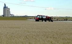
Deciding when to turn on the tap and by how much is a major management decision for farmers who irrigate.
Teams of hydrologists, soil scientists, agronomists, software specialists and aerial imagery analysts help producers determine the optimal days and water volumes that should be applied to each area of an irrigated field.
One such company is HydroBio of Denver, Colorado, which uses space age technology to make these decisions.
“We do irrigation scheduling prescriptions based on satellite data,” says Barrett Mooney, head of HydroBio.
Read Also

House ag committee to undertake several studies
The House of Commons standing agriculture committee has set its agenda for the coming months. Members began the fall sitting with a two-hour update on international trade
“We do a modern, high tech version of the old PE2 system with pans in the field, but we’re far more accurate because we use every pixel as its own individual pan. We can zoom in to look at 1/20th of an acre if we need to. That’s great for operators doing variable rate irrigation so they only put water down when and where it’s needed.”
There are about 1,100 satellites orbiting Earth and snapping photos, which gives HydroBio plenty of images from which to choose. Resolution ranges from three to 22 metres, depending on which source is used. Average resolution is six metres.
Mooney said HydroBio’s interpretation of the imagery tells the customer how the entire field is performing in terms of water use efficiency. It can also report on specific areas.
The goal is to give a crop the optimal volume of water it needs to hit the performance goal. Too little water prevents a crop from hitting the goal, while too much water may have a detrimental effect and waste water.
HydroBio’s scheduling recommendations help producers hit the yield goal, but they also help save water. Saving water saves money, prevents depletion of the water source and supports the long-term sustainability of farming with irrigation.
One of HydroBio’s larger customers told the company that following its irrigation prescriptions to the letter saved it 650 million gallons of water last year.
Mooney said his work with irrigation scheduling began when he used satellite imagery to research ground water infiltration models. That kind of imagery is now common in settling water rights disputes, watershed issues and planning government funded water projects, he added.
“Although water is our main area of expertise, we do track other crop problems for our customers,” he said.
“We don’t determine if it’s insects or disease or nutrition, but we do identify areas in the field where plants are suffering. We also give a producer the severity and extent of the problem area. Of course, if it’s drought stress, we do flag those spots because that’s the business we’re in.
“We do everything we can to streamline the data flow, to un-complicate a farmer’s life. Too much digital data is overwhelming, so we keep the information digestible. Our log-in screen is simple. It gives you an overview of all your fields on the system, current imagery and status. We don’t give you stuff you don’t need.”
Mooney said it’s possible to provide a customer on the other side of the world with the same high calibre service as a customer 15 kilo-metres from his Denver office.
HydroBio has clients in six states and 13 countries. There are no customers in Canada, but Mooney said all it takes is a phone call to put a new customer on the system.
“Here’s how it works,” he said.
“You come to us. We enrol the field, the crop, the planting date and other agronomic details. Then we begin delivering a weekly summary report on how your field is performing versus your irrigation plan or strategy.
“We help determine when the field is approaching its soil water limit and needs more. You can access that field via a web based platform or we’ll email the weekly report. Cost for the growing season is US$6 per acre.”
The work that HydroBio is doing with irrigation farmers might be considered applied science when compared to the pure science work being performed by NASA’s SMAP program, which is building algorithms to predict long-term weather.
Mooney said the SMAP project uses microwave imagery to assess soil moisture levels.
“We have a different approach. We actually created our own vegetative index to do a crop analysis.
“So instead of looking at just the current soil water in the top three inches (eight centimetres), which is what SMAP microwave technology does, we instead look at what the crop is using. And then with weather and irrigation data from stations in the field, we actually look at how much water is entering the system. It’s a simple account balance system.”
SMAP agricultural co-ordinator Michael Cosh said his project also creates a vegetative index that’s compatible with some satellites. It’s necessary to separate vegetative data from soil moisture data.
“The human eye sees red, green and blue light bands,” Cosh said.
“To create a vegetative index, you need near optical technology. We use a near infrared signal along with the green band to monitor crop status and get estimates of soil moisture. With that, we can tell you where your crops are stressed.
“To separate vegetation data from data on soil moisture, you need high resolution products from Landsat, Ikonos, SPOT, Worldview or other satellites in the metres scale.
“Once you have soil type and other site specific data on the customer’s field, then you create algorithms. You fine tune those algorithms every week or every time you enter new data. But you have to start with good information on the ground.”