But cooler in Manitoba | Weather Network issues its summer forecast
Mother Nature is releasing her icy grip on the eastern Prairies.
“This pattern is starting to ease a bit, so I do think this cooler trend will start to relax as we get further along into the summer months,” said Gina Ressler, a meteorologist with the Weather Network.
“We will see some of that heat and even that humidity into Saskatchewan and Manitoba, but it might just be a little bit delayed. We might just have to wait a little bit longer into July and August to see that, but I do think it will come.”
Read Also
India slaps 30 per cent import duty on yellow peas
India has imposed a 30 per cent duty on yellow pea imports with a bill of lading date on or after Nov. 1, 2025.
The delay has prompted the Weather Network to forecast a cooler-than-normal summer in Manitoba and eastern Saskatchewan.
Western Saskatchewan and Alberta are expected to have near normal temperatures, trending toward warmer-than-normal in Alberta for late July and August.
“They may see late summer heat, especially closer towards the Rockies,” said Ressler.
Most of the grain belt should experience near normal precipitation.
“If I were to go one way or the other, I would err on the side of maybe wetter than normal, at least for the beginning of summer,” she said.
The forecast calls for a wetter weather pattern for northern Saskatchewan and Manitoba. Alberta could switch to a drier trend by late summer because of the warming influence.
Ressler has less confidence in the precipitation forecast than the temperature forecast because much of the summer rain comes in the form of thundershowers, which are difficult to predict.
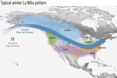
A developing El Nino is the main reason the forecast calls for warmer temperatures in the western Prairies toward the end of summer.
Ressler is confident an El Nino will materialize by late summer or early fall, but there is plenty of debate among meteorologists over how strong it will be.
“There has been a lot of talk in the last month or so comparing this event to the 1997-98 Super El Nino that was one of the strongest on record,” she said. “We don’t expect it to be as strong as that.”
The Weather Network is forecasting a moderate El Nino, while AccuWeather and the Commodity Weather Group are forecasting a weak event.
Ressler said a weak El Nino wouldn’t change her forecast for the weather pattern on the Canadian Prairies.
Other factors will influence temperature and precipitation, such as the warming of the North Atlantic Ocean, which is causing a ridge pattern to set up over the West Coast that will influence summer jet streams.


