SAIRS (Shearer Agricultural Imaging & Remote Sensing), based in Yorkton, Saskatchewan, is an ag-tech innovator driven by on-farm ingenuity and digital precision. Their leading product, StoneSight, is an AI-driven stone mapping system designed to optimize efficiency and precision in agricultural operations. Harnessing machine learning and open-source data, StoneSight creates detailed, navigable maps of field-embedded stones — dramatically increasing stone-picking efficiency for farms across Manitoba and Saskatchewan.
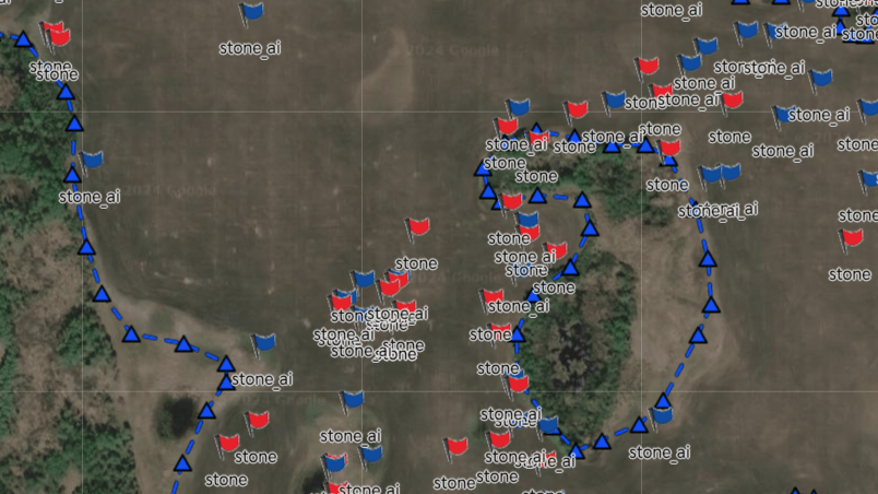
The system is a true farm-built solution. Mounted to equipment, StoneSight captures video footage during normal field operations. This imagery is uploaded to the cloud, where AI algorithms analyze it — identifying surface stones across multiple size thresholds (approximately 15 cm to 40 cm in diameter) — and returns a precise, high-resolution stone map to the operator. While the detection is near real time, by the time the data is retrieved from the machine, uploaded, processed and a map returned, farmers typically receive “next day” maps. This equips them with actionable intelligence for more efficient land preparation, ultimately reducing time and labour costs, machinery damage and mental fatigue.
Kevin Shearer, founder of SAIRS, has been running field trials for the past two years on JB Farms in Manitoba’s Parkland region. Unlike traditional stone detection methods, StoneSight delivers highly accurate stone location data across thousands of acres, optimizing stone management like never before. “With over four decades of rock picking behind me, I can confidently say this system truly makes the job easier and adds real value to the farm,” says Shearer.
StoneSight’s progress reached a pivotal turning point through a strategic collaboration with SoilMate.AI, whose expertise and technology were instrumental in enabling near real-time stone detection — something that wouldn’t have been possible without their partnership. Reflecting on the system’s evolution, Shearer added: “It’s been rewarding to take something built out of necessity on the farm and push it to the edge of what today’s technology allows. We’re not just building tools — we’re solving real problems producers face every spring and fall.”
As SAIRS continues to refine StoneSight’s capabilities and expand its technology partnerships, this innovation stands as a compelling testament to how farm-grounded design, AI and cloud-based geospatial services can reshape the landscape of stone management in modern agriculture.
Learn more or book a demo at www.sairs.ca/stone-sight-stone-mapping and see how StoneSight can transform your field prep this season.