A research project that uses photos from space could help farmers save a few dollars in insurance payments.
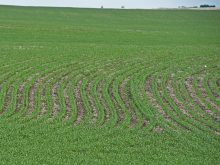
The idea is to use satellite-generated images to track, identify and map crop damage from hailstorms.
Better maps will help streamline the assessment process, says Jim Finnigan, president of Digital Environmental Management, a Saskatoon company specializing in environmental applications of remote sensing technology.
Over the long run, that should reduce the cost of administering crop insurance.
“Hopefully that saving is passed on to the guys that are paying the premiums,” he said.
Read Also

Agri-business and farms front and centre for Alberta’s Open Farm Days
Open Farm Days continues to enjoy success in its 14th year running, as Alberta farms and agri-businesses were showcased to increase awareness on how food gets to the dinner plate.
“That’s the goal.”
The satellite images will indicate the percentage of damage in a particular field, probably using a quarter section as the base. The images will be made available to insurance companies and farmers.
DEM had a display booth at Canadian Western Agribition two years ago to tell farmers about the agricultural applications of remote sensing from satellites.
The company wondered whether producers might object to the idea of being “spied on” by satellites.
“But the reaction was, ‘if you take those pictures and it helps bring my hail premiums down, then go ahead and spy,’ ” Finnigan said with a chuckle.
DEM’s hail-storm mapping project was one of 18 contracts that the Canadian Space Agency awarded to companies with applications that could be used with the new Radarsat-2 satellite, scheduled to be launched in 2005.
The company has already successfully done similar work using the Radarsat-1 satellite, but the new satellite will possess technology that produces clearer and more definitive images.
While the Radarsat-1 satellite was not ideally suited for monitoring vegetation, it did demonstrate the potential for using remote sensing systems to map crop damage.
Radar is sensitive to moisture and surface roughness. When hail strikes a standing cereal crop, the smooth, uniform surface become irregular and shows up on the satellite image. The camera can also detect changes in a crop’s moisture content caused by the storm.
Between now and the launching of Radarsat-2, DEM will receive images from the European Space Agency’s Envisat satellite. The Europeans agreed to provide $50,000 worth of images at no charge as a form of research grant.
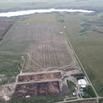
This year’s research will collect information every two weeks from two test areas: around Vanscoy in central Saskatchewan and around Frontier in the southwestern part of the province. Each test area measures about 100 kilometres by 100 kilometres and images of storms within those boundaries will be examined and compared with data gathered on the ground.
Finnigan said the company eventually plans to post its maps on a website so farmers can check out hail damage to assist them in meeting hail insurance companies’ reporting deadlines.
“If you have fields all over the place, you might not even know a hailstorm occurred,” he said.
“It will really help farmers if we can get maps out in a timely way.”He said the company will use this year to fine tune its methodology to ensure accuracy.
“If we say there was a hailstorm, we have to be right,” he said.
“So we’re really going through a process of making sure we’re always right.”