MORINVILLE, Alta. – Mother Nature turned on the taps above northwestern and north-central Alberta, causing swollen rivers to submerge thousands of acres of farmland.
Hector Goudreau, an Alberta Agriculture crop specialist based in Falher, said between 110 and 130 millimetres drenched his region since June 15.
After touring the Municipal District of Smoky River to assess the damage, Goudreau estimated the torrential downpour could cut crop yields by up to 25 percent in the area, about 300 kilometres northwest of Edmonton.
“Up until last Friday (June 14), our ground was saturated and our crops were doing quite well. Farmers struggled to put in the crops but about 98 percent managed to get finished,” said Goudreau. “By Wednesday (June 19) afternoon, we estimated one-third of our sown acres were under water.”
Read Also

Organic farmers urged to make better use of trade deals
Organic growers should be singing CUSMA’s praises, according to the Canadian Chamber of Commerce.
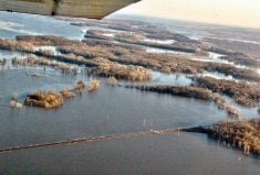
The precipitation caused the Little Smoky River to spill over its banks, forcing a few families with farms along the river to flee to higher ground.
Despite the heavy showers, Goudreau believes sunny skies will repair most of the damage.
“But in some low spots, the water will stay until the fall,” he added.
Even under the most favorable scenario, Goudreau predicts last week’s cloudburst will cut wheat yields between 10 and 25 percent.
“We’ve probably lost about 30 percent of our pea crops,” he said.
For Claude and Bernadette Levesque, who farm 10 quarters near Falher, the heavy rains represented a troubling irony.
“In April, we were really worried about getting enough moisture,” said Bernadette Levesque. “We even bought a new drill to make sure we were getting that moisture.
“About two weeks ago, there was maybe three inches of rain that fell on our quarters. The canola there was coming up pretty good.”
Field of blue
But last week’s downpour submerged about 50 acres of canola and dug crisscrossing channels into the field.
“The problem is all the input costs we put into the land, the chemicals and everything. We are just hoping we get some of the costs back,” she said.
“It will all depend on how fast the water recedes. Nothing can move very fast because of the hardpan,” she said. “It makes us worry. Is the water going to recede enough to salvage enough of our costs?”
Homes evacuated
Farther south, heavy rains forced 750 Driftpile residents to flee their homes June 19. The Driftpile River’s rushing waters deluged the small aboriginal community, located about 250 kilometres northwest of Edmonton, and closed a stretch of Highway 2, Alberta’s main north-south route, near the Lesser Slave Lake’s shore.
Farmers in the Sturgeon area, 30 kilometres north of Edmonton, also face crop losses after 85 millimetres of rain swamped the area in the past week.
John Hladky, an Alberta Agriculture crop specialist based in Morinville, predicted the downpour, combined with colder weather earlier in the spring, could cut the region’s yields as much as 20 percent.
“I think the area most at risk would be west of Highway 2. It has a hardpan, which doesn’t allow the water to seep through. The water basically forms into big ponds or lakes.”