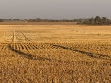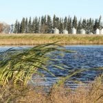

Aerial imagery maps contours of the land, allowing farmers to see where pools of water form and drainage is needed
BANFF, Alta. — Geomatic technology offers farmers a way to manage standing water and soggy fields.
Aerial imagery using cameras and lasers mounted on drones, helicopters and airplanes can track natural drainage and saturated areas in a field, Curtis Parks of Rocky Mountain Equipment said at the Decisive Farming conference held in Banff Dec. 8-9.
The technology uses a laser capable of scanning through a tree or crop canopy to show the contours of land, height of trees and drainage.
The drainage analysis shows where water travels and pools in a field. Creeks, sloughs and areas of standing water can be pinpointed.
Read Also

Phosphate prices to remain high
Phosphate prices are expected to remain elevated, according to Mosaic’s president.
As well, new technology is in development to measure depth of the pools, said Steve Gillis of the company.
By tracking the problem spots, recommendations and plans can be made for better water management.
“Not having water standing around makes it easier for both you as a farmer and the plants in your crop,” Gillis said.
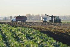
Too much or too little water can result in lost acres, additional inputs, reduced yields and flooded areas that yield nothing.
“Your yield is diminished the closer you get to those water holes. You also have to delay or it may not get seeded or harvested,” he said.
Rocky Mountain Equipment Systems took over Geomatics last year and added the ability to survey fields to its repertoire.
A geomatics system can survey the area and help formulate plans for land levelling, drainage ditches or tiles at the proper locations.
Because it can be carried out while the crop is growing, it leaves time for planning the best solution.
An aerial survey conducted before any water control plans are instituted also helps ensures accurate data is available to applicable regulatory agencies and can play a role in providing proper information to neighbours about planned changes.
“The moment you have negative impacts as a result of water, you can begin to work on a solution beforehand,” Gillis said.
“Before you even touch the field with a ditching implement or tile installation, you know exactly what you are doing and where you are doing,” he said.
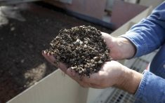
The drainage tile pipes have perforated holes to allow in the excess water, which is then carried away. There is less damage to topsoil and water is carried away in wet years.