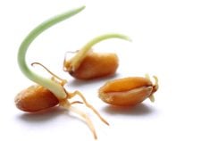
With the click of a mouse, Manitoba producers can keep abreast of whether fusarium head blight may pose a threat to their cereal crops during the growing season.
A forecasting service gathers data about rainfall and temperature from a network of weather stations across the province. That information is then interpreted to produce a risk map for various Manitoba regions. Areas of the map are red where the risk is high and yellow where it is lowest.
The service is provided through the Manitoba Agrometeorological Centre of Excellence, also known as ACE, based at Carman.
Read Also

Equipment manufacturing may return to Canada
Some ag equipment and automotive manufacturers are now adjusting their production and distribution to avoid tariff costs in relation to supplying the Canadian market.
Producers who want frequent risk forecast updates for their immediate area can subscribe through ACE and get reports via e-mail or fax.
There is also an option to lease or buy a weather station and have that data interpreted by ACE for forecasts that are more specific to individual farms.
Fusarium forecasts typically are updated daily on weekdays from late May through to mid-July. That’s when cereal crops are most at risk of infection.
Provincial plant pathologist David Kaminski said the forecasting generally works well, but there are occasional glitches. In 2002, a study was done to see if the forecasts matched what happened in farmers’ fields.
“We found positive indicators that the model is telling the truth.”
There may be times when an area of the forecasting map is blanked out. That happens if a weather station is knocked out, which would skew the data fed into the computer making the forecast for that area.
The service can sometimes miss the mark when identifying the risk of infection, Kaminski said. That tends to happen when moisture and temperature are at levels where the risk normally would be interpreted as high, but the humidity stays below 90 percent. Serious infections tend to occur when humidity levels rise above 90 percent.
The forecasting service is responsive to changes in moisture and temperature, meaning that it lowers the risk when dry conditions arise just as quickly as it increases the risk during bouts of warm, moist weather.
As a tool to help producers decide whether to apply fungicides, Kaminski said the forecasting service can have economic and environmental benefits. Knowing when the risk is below the threshold for applying a fungicide can save producers money while helping reduce the amount of pesticides used in agriculture.
It’s up to producers or their agronomists to decide whether the service suits their needs.
“We always try to encourage integrated pest management,” said Kaminski, “not to the exclusion of pesticides, but by using pesticides judiciously.”