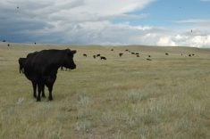
Poor planning has fragmented the prairie landscape and failed to preserve valued natural areas, says an environmental design professor from the University of Calgary.
“Could municipalities independently or regionally address the cumulative effects of environmental degradation?” Richard Barrs asked during a discussion about the impact of inconsistent planning and jurisdiction conflicts in Alberta and British Columbia at a grasslands conservation conference in Calgary Feb. 26-29.
He said Alberta municipalities have the power to approve land use, but rules are not consistent.
Land subdivision remains unchecked in the province, he added, even though many municipalities say their priority is to protect agricultural land.
Read Also
Canadian Food Inspection Agency slammed for handling of bovine tuberculosis case
The federal government leans heavily on producers to “take one for the team” and risk their livelihoods without any reassurance of support.
A regional planning scheme would be better to preserve larger tracts and provide consistency when approving future rural subdivisions.
Barrs said Alberta needs to be the catalyst to get regional planning accepted.
Brad Stelfox, a planner who runs Forem Technologies in Bragg Creek west of Calgary, told the conference that solutions come with a degree of pain.
Calgary is experiencing amoeba-like growth as it spreads farther into the countryside, he said, while special lands are being lost to industrial activity in southwestern Alberta along the foothills.
The result is fragmented landscapes, mismanaged recreation and sprawling country residential sites.
“As time goes by and we discuss mitigation strategies, the plausibility of implementing it becomes very low,” he said.
Some broader planning is under way. A cumulative effects study is being conducted on what is known as the crown of the continent – 42,000 sq. kilometres in southeastern British Columbia, southwestern Alberta and the northern regions of Montana near the Rocky Mountains from the Highwood River south of Calgary to British Columbia’s Elk Valley to the Bob Marshall Wilderness Complex in Montana.
The area has extraordinary biodiversity and jurisdictional challenges because of federal, provincial and local controls, as well as privately held land.
Guy Greenaway of the University of Calgary said the Crown Managers Partnership, which consists of numerous land-use groups, is studying layers of activity in the region, including agriculture, energy, transportation, aboriginal lands, protected areas and forestry.
Greenaway, a member of the group, said it wants to know how the land is being treated. For example, it may examine pesticide use and attempt to figure out what might happen to the land in 25 years. It is also measuring the effects of natural processes such as fire, weather and insect activity.
With such information, the group may be able to predict future water needs or make recommendations for protecting some areas.