Saskatchewan won’t be declaring a provincial state of emergency as Manitoba did earlier today as both provinces work to assist residents and assess damage following a destructive rainfall last weekend.
Manitoba’s provincial state of emergency affects Portage la Prairie and the rural municipalities of Portage la Prairie, Cartier, St. Francois Xavier and Headingley.
The province is warning residents to prepare for flood water exceeding 2011 levels.
“We need to be able to take action to protect the safety, health and welfare of Manitobans,” said Manitoba premier Greg Selinger in a media release.
Read Also

Federal budget draws mixed reaction from Canadian agriculture groups
The 2025 federal budget took a step forward in recognizing agriculture’s importance but failed to address pressing challenges like labour disruptions, interswitching and precision technology, say Canadian farm groups.
“Declaring a provincial state of emergency will allow us to take steps quickly to protect people and property in the area.”
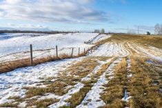
The Manitoba government has also requested assistance from the Canadian military as it reels from a massive rainfall that brought in excess of 240 millilitres to eastern Saskatchewan and Manitoba.
Many areas in both provinces had already received record rainfalls through the spring before last weekend’s event, and water flowing in from across the border is compounding the problem.
“The situation does not require federal assistance, so we’re stable,” said Duane McKay, head of emergency management for Saskatchewan.
Officials reported today that water flows in many affected areas in Saskatchewan are declining, with the exception of the Qu’Appelle lakes.
“Manitoba also receives all of our water and a large amount of water from North Dakota, so they’re sort of at the end of the pipe,” said McKay.
Speaking to Reuters, Brenda Tjaden Lepp, chief analyst at FarmLink Marketing Solutions, estimated the floods ruined one million acres of crops.
The rain may have killed six million acres of crops across Manitoba, Saskatchewan and Alberta, with about 4.4 million of those in Saskatchewan, analyst Larry Weber of Weber Commodities told Reuters. Another 2.1 million acres weren’t planted at all due to bad weather, he said.
Saskatchewan Crop Insurance Corporation has declined to estimate damage to farmers’ fields.
Jim Russell of the Saskatchewan agriculture ministry said provincial officials have received calls about stranded livestock in the Qu’Appelle area.
“Regional staff are working to co-ordinate with producers the best way to get the cattle feed or move the cattle to another area,” he said.
In Saskatchewan, officials report that efforts are moving on to recovery, although 75 communities and First Nations were in a state of emergency as of today.
Fifty-six communities have received designation under the province’s Provincial Disaster Assistance Program.
Residents of Gainsborough who had been evacuated now have access to the community, but without water and sewer service they are still staying in neighbouring communities.
A number of highways in southeastern Saskatchewan remain closed, but highway officials reported that temporary fixes to many damaged roads in southeastern Saskatchewan were progressing, assisting local traffic, although a section of Highway 1 near Wolseley was closed again today because of water running over the road.
A recovery centre has been established in Melville, where area residents can access provincial health, disaster and agriculture officials in one location. It will be open until Sunday.
McKay said centres may be established in other communities, including Carnduff, Moosomin, Broadview, Esterhazy, Balcarres and Yorkton, as recovery progresses.
Warm weather is forecasted for the affected regions in Saskatchewan, and officials are monitoring rising waters on Crooked Lake and Round Lake and the threat of thunderstorms in the province.
“That is not a welcome thing. There’s very little we can do about it so we’re ramping up to ensure that we’re ready to respond to any issues that might present to us,” said McKay.