Crops across southern Manitoba are usually fully emerged by July 15, and it’s almost impossible to see soil from the highway because the vegetation is so dense.
That’s not the case this year.
Many oilseed and cereal crops are patchy because of near record amounts of rain in the western half of the province. For instance, 250 millimetres of rain fell on Brandon in June.
The meager crop stands are also visible from high above the Earth. Satellite imagery indicates the amount of vegetation in Manitoba and eastern Saskatchewan is much lower than normal.
Read Also

Agi3’s AI-powered individualized farm insurance products win innovation prize
Agi3’s AI-powered individualized farm insurance products won the business solutions prize in the Innovations Program Awards prior to the Agriculture in Motion farm show in Langham, Saskatchewan.
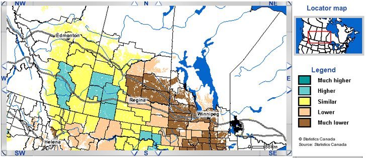
Gordon Reichert, senior scientific adviser with Statistics Canada’s Crop Condition Assessment Program, said a large portion of western Canadian cropland is less verdant than previous years.
Reichert and other federal government scientists use satellite images to measure the amount and greenness of vegetation in Canada to assess the status of agricultural crops.
A satellite map of Western Canada, which can be found by following the links at www26.statcan.ca/ccap-peec/start-debut-eng.jsp, clearly shows that vegetative development is delayed from Winnipeg to Regina and into northeastern Saskatchewan.
“It’s a sizable area. Manitoba, for the most part, is much lower than normal,” Reichert said.
“I don’t remember Manitoba being that low for the entire province.”
Reichert said the normalized difference vegetation index, which is the program’s measuring stick to assess plant growth, is 30 percent lower than normal for the second week of July in parts of Manitoba.
He said the size of the region with a much lower vegetation index is “disconcerting” because it extends into North Dakota and represents a sizable chunk of the northern Plains.
It’s not unusual for satellite images to detect less greenery than normal in June in Manitoba during flood years, but the crops rebound later in the summer.
This year the vegetation index is well below normal in the middle of July, which means less time for cereals and oilseeds to recover.
“(This) may have implications for reduced crop yield if the warm weather doesn’t come on,” Reichert said.
The satellite data isn’t all gloomy. The vegetative index is normal or higher than normal in western Saskatchewan and Alberta.
However, the July 17 Saskatchewan crop report doesn’t corroborate the satellite data. Cereal, oilseed and pulse crops in west-central Saskatchewan are rated at normal development or behind normal for the middle of July.
Statistics Canada will release yield estimates, based on the satellite data, later in July.