WATERLOO, Iowa – Changing anhydrous ammonia tanks is not high on anybody’s list of things they like to do, even for dealers who sell the fertilizer.
A new remote coupling device allows farmers to put that process behind them –25 feet behind them in most cases.
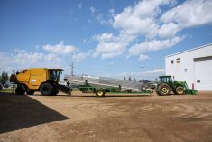
John Deere is releasing the Pitstop Pro connection system for its 2510H anhydrous fertilizer applicator. While aimed at the row crop market, the system has appealing characteristics that could find their way onto other drills.
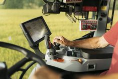
The new automated coupler allows operators to drop an empty fertilizer tank and load another in about two minutes without leaving the tractor cab.
Read Also
Petition launched over grazing lease controversy
Battle continues between the need for generation of tax revenue from irrigation and the preservation of native grasslands in southern Alberta rural municipality.
At the press of a button on the cab’s console, the hose is decoupled from the applicator and with a second button the hitch pin is retracted and the tank and cart are left behind.
Backing into the hitch on the fresh tank connects the cart, and the operator then presses another button to couple the fertilizer line. This causes the coupler on the drill to move down a track and complete the engagement with the tank’s hose.
“In the Midwest on a typical day, with a 1,500 gallon tank and 400 acres to cover, hooking up a tank might happen about 15 times,” said David Wendt of John Deere.
“We can save an hour a day and keep the operator happy too.”
Small baler
New Holland has a new version of its 50 series 14 x 18 baler aimed at hay producers who want to make small bales of 14 by 18 inches for the commercial market.
The BC5070 has a longer bale chamber with a heavier wall designed to improve bale shape and machine durability. Uniform shape is critical for efficient operation of bale wagons.
Hydraulic side tension rails replace the standard hand operated density doors. The new system produces heavier, higher density bales. Cast iron front wedges replace the sheet metal versions found on the lighter duty Hayliner models.
To keep the machine running longer between twine replacements, a new twine box has been added that is one-third bigger than standard and accommodates larger twine balls.
For more information contact www.newholland.com/na.
BRANDON – If a field slopes north but you run your drainage south, there are bound to be problems.
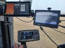
It’s not a unique situation, says Simon Knutson of SK Mapping & GIS Services.
Knutson, who produces elevation maps and drainage prescription maps for Manitoba and Saskatchewan farmers, said he’s no longer fazed when he maps a field that’s been drained for decades, only to find that farmers have been trying to make water run uphill.
“We’re not surprised anymore, but we generally find that farmers are very surprised with what we find,” he said. “We did a 400 acre field up in the Interlake last week. All the water was flowing the complete opposite way to what he had thought. The RM put culverts under the road at the south end of the field, but when we mapped it, all the water was flowing north. We thought it looked like it flowed south, too, until we drove it with the quad. Then we got some … high (resolution) aerial photos from 2008 and that confirmed that it drained to the north.”
Information analyzed
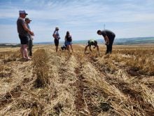
During an AgriTrend field day last month, Knutson translated a satellite photo of a canola field taken the day before. He overlaid the 30 metre pixel satellite image with his topographical map and the drainage prescription.
“First thing in the morning, I translated the sat image into NDVI (Normalized Difference Vegetation Index). From that, I was able to divide the field into four distinct vegetation zones. The AgriTrend team then took my NDVI information and created a variable rate fungicide map for the field where we had the demo that afternoon.”
All this data manipulation took only a few hours, and no time wasted driving to the office. Knutson and the AgriTrend advisers performed the work in the field on laptop computers.
Every field he drives is geo-referenced, so Knutson’s images are quickly overlaid with images from other sources.
Knutson said the Outback-based RTK system costs about $25,000 plus the cost of the all-terrain vehicle.
Although Outback is only single frequency RTK, he said it seems to work fine.
“We’ve done several tests and so far we haven’t found any need to spend twice as much money on a dual frequency system.”
He sets up the typical tripod tower at the field edge. The GPS receiver is strapped to the front of the quad and the laptop is strapped to the back. Elevation is logged wherever he drives in the field.
Knutson charges $10 per acre, which provides the client a topographical map and a drainage prescription map complete with ditch routes, depths and gradients.
For more information, contact Simon Knutson at simon@gis4ag.com.