A pilot project to assess wildlife damage with drones by Agriculture Financial Services Corp. in Alberta’s Peace River district may help document crop damages and assist with timely crop loss assessments.
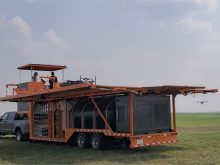
David Tschetter, a farmer, drone operator and photographer with Shady Lane Hutterite Colony at Wanham, Alta., used drone footage on their farm and four others to document crop damage by elk for wildlife compensation claims.
“You get a pretty powerful tool for solving a lot of issues,” said Tschetter.
“Because AFSC didn’t have any wildlife damage inspectors when we put in a claim we mapped it out with a drone. We showed it to AFSC and the claim was approved,” he said.
Read Also
Canada told trade crisis solutions in its hands
Canadians and Canadian exporters need to accept that the old rules of trade are over, and open access to the U.S. market may also be over, says the chief financial correspondent for CTV News.
“All of our fields got assessed and we received our payout.”
AFSC provides Alberta farmers with crop and livestock insurance and other financial services.
Since 2000, the Wanham colony has embraced technology for mapping pesticide and fertilizer-use efficiency. It was a natural progression to adopt drones for assessing crop damage from hail, drought and wandering elk.
Tucked between coulees, parks and wooded areas, the colony expects certain fields will have wildlife damage every year. AFSC’s Wildlife Damage Compensation Program pays compensation for wildlife damage to unharvested crops, but the fields must be inspected before harvest.
With many claims and few inspectors, sometimes the harvest happens before the assessors arrive. That’s when Tschetter decided to fly his drone in front of the combine and swather to document the damage.
In a 2021 news release, AFSC announced it was partnering with Olds College to use drone imagery in hail-damaged fields to assist with assessments. In 2022, the college planned to use drones to visit hail-damaged fields to classify hail-damaged areas and create a database to assist adjusters.
Knowing AFSC had a pilot project to use drones to assess hail-damage claims, Tschetter worked with the agency’s development team to use his drone footage to help develop algorithms to assess what elk damage looks like in the field.
“We are now just watching how the software development continues.”
It is not the first time Tschetter has taken to the air to assess damage. He has hung out the window of an airplane to take pictures, download them onto a computer and manually calculate damage.
“It was very accurate, but time consuming.”
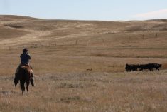
Elk wandering through crop and forage fields have cost Peace River region farmers millions of dollars in damage over the years. With elk herds expanding, accurately documenting the damage may be the only way farmers can coexist with the herds.
“I have worked with other producers who saw the benefits of having their field mapped and worked with AFSC to push those applications through. It provides high accuracy and high efficiency and takes the human eye right out of the equation.
“Drone technology will come to crop insurance and crop health reporting. It is just going to increase in use. There is no reason they wouldn’t continue.”
Adam Fitzpatrick, chair of the Agricultural Service Board with Saddle Hills County, said elk cause millions of dollars damage to area crops, including his.
“Wildlife damage is massive. It doesn’t take a lot of time for a herd of 50 animals to do a pile of damage in a crop.”
Getting an inspector to assess the damage before harvest doesn’t always happen, said Fitzpatrick.
“If I can put up a drone and fly the field and not stress about when the wildlife damage inspector is coming, that is all the better,” said Fitzpatrick, of Savanna.
Billi Comstock, a former AFSC adjuster in the Peace River area, said drones have a future in measuring elk damage, but there are still bugs to work out. The program she used to measure damage had a difficult time differentiating a slough from elk-damaged crop.
But, she said, sometimes it is uncannily accurate. In one field she walked, she estimated 11.2 acres of damage. The drone images estimated 11 acres of damage.
As an aid in helping assessors it is invaluable, said Comstock, who spends hours each summer and fall travelling thousands of kilometres to assess wildlife damage.
“During combine season, it’s pretty hard for one person to be at every quarter.”