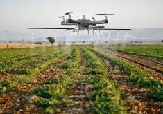
A University of Saskatchewan researcher is using drones to study the correlation between the thermal temperature of a plant and water stress, which typically means a shortness of water.
“I’m using UAV (unmanned aerial vehicle) to collect the thermal electromagnetic radiation that comes off of crops and using that to correlate it to crop volumetric water content in the soil to try and create a relationship,” said Emily Cline, a master’s student in civil engineering at the U of S who is doing her thesis research on the subject.
Read Also
Huge Black Sea flax crop to provide stiff competition
Russia and Kazakhstan harvested huge flax crops and will be providing stiff competition in China and the EU.
The two-year project is expected to wrap up this fall once the crop is off. They have been flying the drone over different crop plots and quarters of land once a week to get thermal images, with pixels every metre.
Evan Derdall, a research engineer at Agriculture Canada who is Cline’s project supervisor, told a recent field day at the Canada-Saskatchewan Irrigation Diversification Centre near Outlook, Sask., that drones are the best way to exercise thermal technology.
“To get a full infrared, that’s basically our only option right now,” said Derdall.
“There’s satellite thermal infrared sensors, but the resolution, you’re looking at a few pixels per quarter section.”
Other satellite technology, such as normalized difference vegetation index (NDVI), is much more advanced than infrared and paints a clearer picture. However, for the purpose of this project, they need the drones to gather the necessary details.
Being able to get a detailed relationship between the thermal imagery and water content will help farmers know when and how much to irrigate.
Typically, what I would expect to see is a warmer canopy indicates more water stress,” said Cline.
Sufficient water supply allows the plant to cool itself, similar to humans when they perspire. Too little, and it will overheat.
“As the plant is transpiring, it’s basically sweating or breathing,” said Derdall.
“If there’s not enough water, it’s going to start conserving, so it’s going to shut down and it won’t transpire enough, so its temperature will rise.”
The hope is once the temperature-water relationship is determined, farmers or contracted companies will be able to monitor the temperatures using drones, and eventually use satellites when the technology becomes more advanced.
While water stress typically causes the change in temperature, Derdall said other factors may contribute, which makes thermal a less-than-exact science.
“One of the disadvantages of remote sensing like NDVI or thermal is that you don’t know for sure what’s causing it. You use it as a guide to determine what’s likely causing it because plant stress is what you’re reading, but it could be water stress, nutrient stress, or heat stress.”
However, if you’re managing your nutrient management and have proper drainage, it’s likely water stress affecting the temperature.
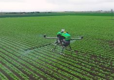
In a similar drone project funded by the Agricultural Development Fund, Phillip Harder and Warren Helgason are using drones equipped with light detection and ranging (lidar) technology.
The lidar uses lasers that hit target points of the canopy and ground to measure the height and density of the crop canopy. Many lasers reflect off the top of the canopy, but any gaps will have the lasers hit the ground, giving them an image of the vegetation.
Helgason, an associate professor at the university’s department of civil geological environmental engineering, is Cline’s academic supervisor. Harder is a research associate at the Centre for Hydrology.
Harding and Helgason fly over different quarters of land with the lidar, getting up to 200 million points of data and 150 points per square metre.
“We’re hoping to demonstrate that this is a more robust and reliable way to quantify crop variability versus multi-spectral approaches,” said Harder.
“We’ve also got this really good, more direct understanding of our crop variability in season, so we can start looking at ‘how does our more indirect approaches, like our multispectral, how well are they working?’ ”
Harder said measuring the special variability of the crop can give farmers a stronger sense of what is going on in the field.
“When it comes to spatial variability, you either have a lot of biomass sampling, which is destructive, or you’re going to tie it back to a yield map at the end of the season,” said Harder. “You’re going to miss what’s happening during the season in terms of variability.”