
Wyvern spends time working on understanding what prairie crop plants are saying through hyperspectral readable emissions
A Canadian start-up is developing satellites that use high-resolution hyperspectral imagery to monitor and improve broad-acre crop production.
Chris Robson is the chief executive officer of Edmonton-based Wyvern, and he said the optics the company plans to launch on the satellite next year will enable a different kind of image analysis that opens new possibilities for monitoring crops.
He said the pixel size will start off at five metres, and then will be improved upon over time.
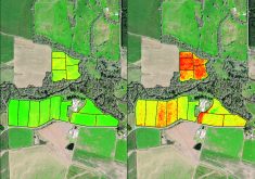
“The unique value proposition is that it’s hyperspectral, which means that you have up to 10 times or more colours than regular imagery. That means that you can identify unique characteristics of agricultural production or crops that wouldn’t be available today,” Robson said.
Read Also
Alberta cracks down on trucking industry
Alberta transportation industry receives numerous sanctions and suspensions after crackdown investigation resulting from numerous bridge strikes and concerned calls and letters from concerned citizens
DragonEye will be Wyvern’s first satellite. It will be equipped with one-metre VNIR (visible and near infrared) and five-metre SWIR (short-wave infrared) cameras. It will unfold similar to the James Webb telescope launched in late 2021.
“This kind of hyperspectral imagery has been of interest in the research community for quite a while, but it has been limited because there’s no real scaling opportunities. There’s no satellite that can do really massive areas and do that on a commercial scale,” Robson said.
If successful, DragonEye will provide hyperspectral satellite imagery on a very large scale, which will allow for the monitoring of colour signals emitted by crops.
“Invisible to the human eye are these signatures that appear during the plants growing cycle, and if you can identify those with those extra colours and tie it to an actual event like a disease or a nitrogen deficiency. We’re focusing a lot on fertilization,” Robson said.
By April 2023, Wyvern hopes to have three satellites in orbit, and then quickly increase the numbers to up to 30 satellites.
This will be helped by $4 million in federal government funding it received in early February from Sustainable Development Technology Canada.
The investment is tied to a three-year project that includes support from Xarvio Digital Farming Solutions, Olds College, SkyWatch, Metaspectral, and Wild + Pine as partners.
Xarvio offers digital solutions for agriculture including algorithms that can differentiate plants and weeds in images in real time.
SkyWatch connect developers and GIS managers with networks of satellite imagery providers.
Metaspectral sells products for multi and hyperspectral data management.
Wild + Pine develops net-zero carbon capture projects through the restoration of Canada’s forests.
Wyvern also received US$4.5 million in funding and acceptance into the Y Combinator accelerator, which provides seed funding for start-ups.
Robson said he’s excited to work with Olds College Smart Farm and its Hyper Layer that monitors production fields with a host of sensors.
This summer, even before the satellites are launched Wyvern will help identify some of the colour signals emitted and measured with its hyper spectral cameras by a crop mean.
“The idea is that let’s try to measure stuff in this really controlled environment and then once the satellites are available, we can expand and scale that learning across Western Canada. So, if you could say identify clubroot or blackleg earlier, or if you could identify nitrogen content or soil carbon. Those are some of the things that we’re really looking at,” Robson said.