
Service produces maps of soil types and properties that agrologists, farmers can use to be more precise
A new predictive soil-mapping service will be available in Saskatchewan this spring for farmers and agronomists who want to participate in the system’s beta testing.
The service is available through the Saskatchewan Soil Information System (SKSIS), which was developed by a research team in the University of Saskatchewan’s soil science department.
The SKSIS is a web-based platform, available at www.sksis.ca, that predicts the soil characteristics across fields by combining a digital elevation model and geolocated soil data.
Users select a point on the online map and information is displayed from the polygon where the point is located, including soil class and parent material, texture, salinity and agricultural capability.
Jeremy Kiss, a research associate in the soil science department, said the SKSIS was never intended to help with management within a field.
“That would be the purpose of this new platform, the predictive soil mapping service, a.k.a. SKSIS Mapper. So, this is another web-based platform that we’re developing,” Kiss said.
“The target user base is really agronomists who already incorporate some GIS technologies into their workflow, but certainly, anyone who’s interested in trying it out. If you’re a savvy producer interested in mapping the soils in the field, you’re certainly welcome to use it as well.”
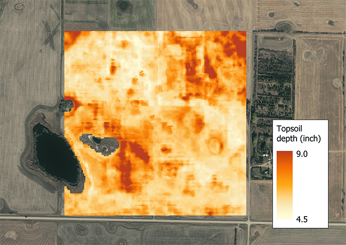
He said the core function of the SKSIS Mapper is to build site specific maps using user-uploaded input data, which includes geo referenced soil point data for the target property that users want to map.
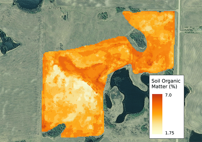
For instance, if a user wanted to map the soil organic matter across a field, they would measure the organic matter at points across the field.
This information is then combined with the system’s digital elevation model as well as other remote sensing derivatives, including vegetative maps, to generate an organic matter map of a field.
“Some of the things we’ve had success mapping at these site-specific levels is organic carbon, soil organic matter, profile classifications, topsoil thickness, soil texture,” Kiss said during a presentation he provided at the U of S’s Soils and Crop conference.
He said a PhD student is working on a technique for mapping salinity based on remote sensing variables for use in the SKSIS Mapper.
Kiss said he doesn’t claim the SKSIS Mapper can reliably map the more dynamic properties such as values for available nutrients, including nitrate or available phosphorus at a specific point.
“But, with that said, I do think this has an enormous potential for informing nutrient management, through mapping more stable properties that are indicative of nutrient availability,” he said.
“Organic matter, as we know, is highly reflective of your nutrient availability, and similarly topsoil thickness. So, these maps can help you to come up with plans of how you’d manage nutrients and how they relate to measurements of the more dynamic properties across the site.”
The SKSIS Mapper does not provide management prescription recommendations, including variable rate fertilizer maps or delineating specific management zones.
“The idea here is about generating maps and spatial information to put into the hands of agronomists who can translate that with their know-how into those management decisions. So, the soil maps could be used to inform management zone creation,” Kiss said.
The maps created by the SKSIS Mapper can highlight underlying soil issues that affect productivity, and when used in conjunction with other tools including satellite or aerial NDVI imagery, users can understand quickly what caused an issue.
LIDAR imagery is not available in Saskatchewan, so a case-by-case collection of elevation data is necessary. This can be done with drone imagery, including an RGB camera, or even through farm equipment equipped with RTK GPS, although the data quality from this method can be variable.
Kiss said this will be limit users’ ability to use the platform, so the team is looking into more ways to create the elevation maps, including potentially generating an elevation module from publicly available Sentinel One radar imagery.
A feature for the SKSIS Mapper under development is a module that can generate optimized soil-sample designs.
“A user would upload a digital elevation model, and that would be used in combination with other remote sensing variables to generate GPS locations for the optimal sampling locations across the site,” Kiss said.
He said this sampling module is based on existing methodology that was modified for the Saskatchewan landscape to ensure that important topographic features are covered.
Another module is being developed to support slope position modelling, which will be used when an elevation model is available but soil point data is not.
“We could generate a map of these simplified slope positions, like depressions, low slopes, mid-slopes, upper slopes and crests, which can be important and useful for economic decision making,” Kiss said.
He said the default setting for the system is to not share users’ data with the developers, but if users choose to share their data it will be used only to help build better modules.
The SKSIS Mapper will be available as a subscription service at an inexpensive rate.
“We are planning to launch the platform later this year, and if anyone is interested in testing it out as a beta tester, please contact (sksis_support@usask.ca),” Kiss said.