Bob Cormier starts his weather presentation with an apology.
“Sorry about not doing something about it, but I can tell you what might happen over the next year,” the Environment Canada meteorologist told producers attending Crop Production Week in Saskatoon Jan. 10.
Cormier said prairie producers can expect a cold period of three months or more, starting in February.
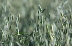
Spring and summer on the Prairies will likely be cool and potentially wetter than usual.
Fall might deliver more precipitation in mid-September, as has been the trend for the past couple of years.
Read Also

VIDEO: Ag in Motion documentary launches second season
The second season of the the Western Producer’s documentary series about Ag in Motion launched Oct. 8.
Cormier said weather patterns have changed during his 34 year career studying weather.
“Since the 1950s we have seen the average annual precipitation remaining fairly steady. But when we get it, that is what is changing.”
Cormier said drier winters, wetter falls and steady spring and summer precipitation tend to be the trend.
Global warming isn’t significantly affecting prairie temperature, but one trend is higher overnight temperatures during the winter, which may be a boon for winter cereal growers.
During the 10 La Ninas recorded since 1950, the Prairies experienced cold, snowy winters that hung on into early spring, adding to seasonal moisture and keeping producers off fields.
La Ninas occur when sea surface temperatures drop about one half of a degree C or more in the Pacific Ocean. They typically last five to 10 months.
Cormier said Environment Canada forecasts for January to March are calling for below normal temperatures and above normal snow in Western Canada. These forecasts have a good chance of being accurate, he added.
“In my 34 years of forecasting I can tell you that in the absence of a La Nina or El Nino year, our (long range) forecasts are about as good as a coin toss. Winter forecasts tend to be more accurate than summer, but when we have an El Nino or La Nina year the forecasts lean heavily in favour of the forecaster – 65 percent or better on temperature and a little less on precipitation.”
He said Canadian forecasters now regularly adjust for the effects of global warming and its two to three degree increase in average temperatures. This means that a forecast of what might typically have been low temperatures during a La Nina year still applies, but those temperatures will be higher than in La Nina years of 20 years ago.
As a result, the temperature forecasts for this spring and summer will appear more like what producers might expect to observe in an average year.
Cormier said this year’s La Nina will likely produce more snow for extreme southern areas of the Prairies because of more frequent low pressure systems passing through the American northwest and west.
Precipitation will likely be higher than average across the Prairies this spring and into summer.
“Relatively cooler summers produce more showers and I expect we might see this trend to continue,” he said.
“Since the 1950s we have seen higher moisture levels in most of the La Nina event years and I expect we might see this again in 2008.”
In previous La Ninas, with the exception of one in the 1980s when there was 18 percent less moisture in Western Canada, the Prairies have had above average precipitation with more showers.
“Not likely a real dry summer coming,”he said.
Predicting the weather
What we know
Temperature changes that are likely due to global warming are increasing more over the Prairies and the Arctic than in the rest of the country.
More precipitation changes are seen in the rest of Canada with no change on the Prairies. In the West there is less moisture in winter and more in fall.
Incidents of severe summer weather is staying the same, but winters are seeing fewer blizzards and extended periods of cold.
What we might know
Temperatures across Canada will rise overall and summer temperatures might rise on the Prairies.
There will be more storms between November and March, but they won’t necessarily produce more precipitation, due largely to warmer winters that don’t contain the large, stable, cold air masses they once did.
What we don’t know
It is difficult to accurately predict severe summer weather.
Seasonal distribution of precipitation will continue to be difficult to predict on the Prairies.