
Western Canada’s potentially devastating flood situation gained a measure of clarity this week and the picture that is emerging could be an ugly one, say farmers, municipal officials, provincial water authorities and hydrology experts.
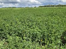
Across the Prairies, soil moisture reserves are at unusually high levels, meaning the potential for runoff is greater than normal.
The winter snowpack was also heavier than usual, particularly in the eastern half of Saskatchewan.
As a result, landowners are expecting an extremely wet spring, complete with saturated farmland, sloughs and wetlands that are filled to capacity, creeks and rivers that are spilling their banks and significant unseeded acreage.
Read Also

Manitoba Parkland research station grapples with dry year
Drought conditions in northwestern Manitoba have forced researchers at the Parkland Crop Diversification Foundation to terminate some projects and reseed others.
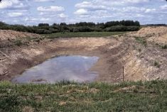
“In many parts of the Prairies, we have extremely high snow packs but what we also have … are large areas where almost all of the depressional water storage is filled up,” said John Pomeroy, an expert in prairie drainage at the University of Saskatchewan.
“Almost all of the capacity is filled in certain areas and the soil moisture is saturated or close to it …. These areas simply cannot hold any more water when the snow melts.”
According to Pomeroy, the extent of flooding damage will hinge on how fast the snow melts.
Delayed spring warming and a sudden shift in temperatures could have a devastating impact, he said.
“What I’m particularly worried about is if we have a late melt… where we get into mid or late April and the cold weather breaks and we get extremely warm temperatures,” Pomeroy said.
“I think it’s worthwhile to say that this could be a runoff event, in some areas, that has never been experienced since settlement. We have the potential to get record flood conditions in some regions of the Prairies.”
Satellite measurements produced by Environment Canada show unusually heavy snow packs in many areas, including southwestern Saskatchewan near the Cypress Hills, northeastern Alberta around Lloydminster, northwestern Saskatchewan and west central Saskatchewan in a long ribbon surrounding the Saskatchewan River system.
The entire eastern half of Saskatchewan’s grain belt will almost certainly see widespread flooding and extremely heavy runoff this spring, Pomeroy added.
“We’ve got a research base in southeastern Saskatchewan where we measure snowpack and we’ve got 140 centimetres of snow depth in the field there, which is incredible.”
In Manitoba, a province that serves as a floor drain for most of Western Canada, the situation has the potential to be disastrous.
Steve Topping, executive director of infrastructure and operations at Manitoba Water Stewardship, says the province is bracing for significant flooding along the Red and Assiniboine rivers.
Topping said towns and cities located along the Red are anticipating water levels similar to 2009, when tens of thousands of acres of farmland in the Red River Valley were submerged.
Water levels in the Assiniboine River could also reach record levels, he added.
The Assiniboine River system, which merges with the Qu’Appelle and Souris Rivers, carries water from a large portion of eastern Saskatchewan into southern Manitoba before merging with the Red River at Winnipeg.
“We’re fighting this flood on numerous fronts,” said Topping.
“Manitoba is downstream from everybody and our situation … after the record precipitation that we got last year … is that all of our lakes are full, all of our streams were charged going into freeze up ….”
According to Topping, three major factors will determine the extent of flood damage that occurs in Manitoba this year.
Those factors include the melt rate, the amount of precipitation that falls over the next few weeks and the timing of the melt in different parts of Western Canada and the northern United States.
If daytime temperatures rise sharply prompting a rapid melt, runoff levels are likely to peak quickly, placing additional pressure on the natural waterways and man-made flood control structures.
And if the melt in southeastern Saskatchewan coincides with the melt in North Dakota at the headwaters of the Red River, large volumes of water could converge in southern Manitoba at the same time, putting flood mitigation plans to their ultimate test.
A rapid melt combined with additional spring rain has the potential to bring one of the worst flood events in the province’s recorded history.
“Our February flood outlook said the Assiniboine River will be at 1976 levels … (with an ) unfavourable weather scenario and 1976 levels is quite a significant flood,” said Topping.
“It’s about a one in 100 year flood. “On the Red River, a normal weather scenario (would result) in a 2009-type flood and that was the province’s second largest flood since 1856,” he continued.
“With an unfavourable weather scenario, we would see 1997 type floods and that was the largest flood since 1856. Either way you look at it, this is a significant flood event.”
With so much water destined for southern Manitoba, the province is encouraging rural municipalities and landowners to have emergency plans.
In anticipation of the oncoming deluge, the province has mobilized 150 pieces of heavy equipment to fortify dikes along a 70-kilometre stretch of the Assiniboine River between Portage la Prairie and Baie St. Paul.
Further up river, near Preeceville, Sask., farmer Corwin Tonn has been watching with interest to see what the spring of 2011 holds.
Last year, Tonn mudded in about two thirds of his normal acreage and then watched in disbelief as more than 1,000 millimetres of rain fell on the area between April 1 and freeze-up.
Snowfall this winter has also been heavier than normal, he said.
Although farmers in the Preeceville area are trying to remain optimistic, many are already wondering if they would be better off staying out of muddy fields this spring.
“Everything can change in a heart beat but right now, excess moisture is definitely a concern,” said Tonn.
FLOOD WATCH IN SOUTHERN SASKATCHEWAN
Residents throughout southern Saskatchewan are preparing for heavy spring runoff once the melt begins in earnest.
•The provincial government has announced a flood mitigation program to help individuals and communities prepare, and last week added temporary staff to the office of the Provincial Disaster Assistance Program to clear up the 2010 claims. There are now 52 temporary staff working on those files. Public safety minister Yogi Huyghebaert said claims will be cleared within three months.
•As of March 14, PDAP had received more than 5,900 claims. About 3,900 people have received at least a portion of their claims while 1,100 have been completed. More than $14.5 million has been paid out.
•The government has also launched a website to help people prepare for flooding. The site, www.saskflood.ca , includes updates on floods as they occur, information on PDAP and other programs, maps, charts and flood prevention tips.
•Saskatchewan Watershed Authority has predicted that most of the grainbelt will see above normal runoff.