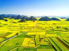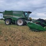
Drought, hail, flood and gophers all present unfortunate risks for this year’s crop.
For farmers unlucky enough to be hit by one of these circumstances, the task of calculating the damage falls to the crop insurance agencies in the prairie provinces.
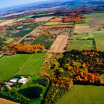
For about the last 10 years, all three provincial governments on the Prairies have used GPS to measure fields and calculate claims.
Darby Warner of Saskatchewan Crop Insurance Corporation said the technology is quick and accurate and allows adjusters and producers to see exactly what has been measured.
Read Also
Short rapeseed crop may put China in a bind
Industry thinks China’s rapeseed crop is way smaller than the official government estimate. The country’s canola imports will also be down, so there will be a lot of unmet demand.
Warner and his counterparts in Manitoba and Alberta said farmers so far have had few disputes with GPS measurements.
Farmers might receive smaller payouts than expected if the measured acreage is smaller than they thought, but would pay lower premiums based on new measurements too, he said. If the GPS measurements show more land than expected, premiums could also be increased.
David Burdett, co-ordinator of adjuster training for Alberta Financial Services Corp., said there were skeptics when the method was first used.
GPS uses 24 orbiting satellites and ground receivers to pinpoint locations. Joining the locations together produces a map.
Some complained the GPS receivers weren’t accurate.
“We took ours out,” Burdett said of the receivers. “(We) hired a land surveyor and he came with exactly the same unit.”
The difference between the two systems was within one-tenth of an acre.
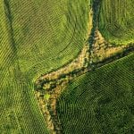
In Saskatchewan, Warner said complaints came from farmers who believed the system didn’t properly measure their hilly terrain. Some people think that the slope of a hill adds significantly to the area.
SCIC hired the University of Saskatchewan to research that concern. Researchers conducted their work in the Bruno area east of Saskatoon where the slope is considered at the extreme limit of what could be farmed.
The project found that the “topography could add as much as one percent to an area,” Warner said.
That means on a 160 acre quarter, the hills could add 1.6 acres.
Warner said the system was also tested for accuracy using markers erected by legal land surveyors.
When Saskatchewan’s equipment was tested against 15 of 16 legally surveyed Canadian Base Station Network pedestals, it was accurate to within 56 centimetres.
That’s greater than 99 percent accuracy.
Before GPS, adjusters used measuring wheels to determine acreage.
Those worked well if fields were square and level, but were more difficult to use on irregular land.
“The problem with the wheel is it was hard to take sloughs into account,” said Burdett.
Craig Thomson, vice-president of insurance operations with Manitoba Agricultural Services Corp., said studies comparing the two systems found they were equally accurate in measuring field size.
He also said that farmers are comfortable with the technology and are using GPS themselves.
The agencies rely to a degree on producers to tell them where the GPS measurements should be taken.
“We don’t go from legal survey markers,” Thomson explained. “We measure fields based on what producers report to us.”
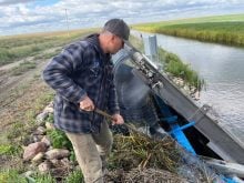
Adjusters use hand-held receivers and walk or drive around the edge of a field to obtain the location. Some have laptop computers in their vehicles and can display images as they develop.
The maps are combined with geographical information systems data to get a precise picture of the land.
Warner said the Saskatchewan provincial grid of quarter sections is then placed over that.
“We get a base map for the province with quarter sections on top,” he said.
Because the land is measured in quarters, and not by field size, a computer will calculate the area within each quarter that is cultivated, slough, bush, rock piles and other features to get a true picture.
Field boundaries may spill over quarter-section boundaries, but the area within each quarter is calculated separately, Warner said.
“We’re measuring cultivated acres,” he said. “We’re not legal land surveyors.”
As well, Saskatchewan uses SPOT satellite images and can overlay them on the maps.
Burdett said Alberta uses the technology mostly after harvest when adjusters are measuring bins. At the same time, they can confirm that a field has been combined and measure it.
“Our policy is that we have to GPS one field of each grain type,” he said.
If a producer claims a field is 120 acres, and AFSC staff find 119 or 121 there won’t be a problem.
“If we’re out more than five acres we have to GPS the others,” Burdett said. “It comes down to honesty.”
Over a period of time, AFSC accumulates field diagrams and obtains a clear picture of what the land looks like.
Sometimes farmers dispute measurements based on the acreage meter readings on their seeders. Usually, the meter measures a higher number.
“The reason for that is how much did you overlap?” Burdett said.
Obtaining the field maps used by crop insurance can also save farmers money by helping to determine the amount of inputs needed. Claims are more accurate and premiums are more stable, he said.
GPS technology also reduces paper forms and it can link the receivers to laptops to complete the calculations.