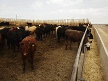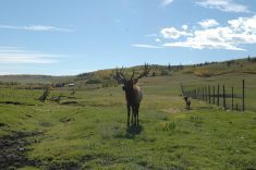

Lakeland College scientists in Alberta hope to help producers who need to graze cattle in difficult-to-access areas
A pilot project in Alberta is using an Australian system of GPS-enabled smart tags on livestock for the first time in North America, allowing researchers and producers to use low-orbit satellites to locate cattle.
Each tag can also monitor the activity level of cows using a built-in accelerometer, said livestock research scientist Susan Markus of Lakeland College. As well, they can measure the ambient air temperature with power provided by a small attached solar panel, she added.
“We’ve got 48 total tags that we purchased initially for this project this summer just to sort of see how the technology works; what we can get out of it for data.”
The devices are made by Ceres Tag, a company founded by Australian ranchers David and Melita Smith. The two-year pilot project involves a research herd at Lakeland College’s campus in Vermilion, Alta., and a separate herd owned by a producer.
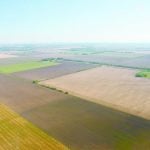
Scientists want to help cow-calf producers who can’t obtain grazing land in the central and southern parts of Western Canada. Instead, they move cattle further north, where it is harder to monitor their livestock due to “lots of bush, forested and treed areas,” said Markus.
“And what’s happening is you send groups of cows out there for the grazing and breeding season, and some of them aren’t coming back pregnant. And so the producer is thinking, ‘is this an issue with bull capacity? Is the bull not finding the cows to breed them? What’s going on with so many more cows than what’s considered typical?’ ”
If producers expect the rate of open cows to be less than seven percent and instead it is twice that, “that’s a huge economic problem, so that’s where the project was developed, and we thought Ceres Tag might be a good fit to help us resolve that issue because then we could track these cattle.”
The smart tags provide GPS co-ordinates for cows, allowing researchers to locate the animals via Google Maps, said Markus. The devices can also track several different levels of activity ranging from none, “meaning the animal could be dead, not moving, or the tag could be lost and it’s just lying there, all the way up to extremely high activity, so probably anything from jumping, mounting, running, those types of things.”
It’s roughly like a Fitbit for cattle, although Markus said the information is not as detailed.
“But for most people’s purposes, if they just want to know where the cattle are and if they’re getting chased (or) running out of the pasture area, then it serves that purpose actually quite well.”
The location can also be correlated with the ambient temperature, allowing researchers to see that cattle experienced heat of up to 35 C this summer when they were in a grassy area out in the open later in the day.
Markus said one of the advantages of the smart tags is their data is transmitted via satellite, eliminating the need for infrastructure such as towers.
A current limitation is their battery life, so data can only be transmitted every four hours, said Heather Mundt, a producer near Oyen, Alta., who is also using the devices. The tags contain a radio frequency identification (RFID) chip but their use for traceability purposes hasn’t yet been approved in Canada, Mundt said.
Separate software such as the Aglive app and platform is also required to operate the tags. However, Aglive integrates directly with the GPS capabilities of the tags, making it possible for “ranchers to market their own meat around the world and prove to anyone, anywhere with verified information that the meat is from their farm or group of farms,” said a statement.
“It’s what is called gate-to-plate traceability complete with a QR code for consumers to scan with their phone and see your website describing the meat they are considering purchasing.”
The potential applications of the tags are “really quite incredible,” said Mundt. “It’s almost like the sky’s the limit what we can do with them.”

Mundt and her husband, Brenton, have partnered with Aglive to help the Australian company Canadianize their program. She became involved after searching for a way to identify cattle that didn’t involve branding them.
“I was watching my husband brand these cows and suddenly I got very emotional about it… so I just started looking for what options were out there.”
The ear tags are held in place by two metal pins and are designed to last up to 10 years.
Although a box of 24 tags costs about $6,000, or about $250 per tag, they allow producers to know the location of a cow in advance, saving them the trouble of physically going out and randomly searching for the animal, said Mundt.
“Ranchers in the mountains that we’ve talked to said that it takes them up to two weeks to round up their entire herd to bring in in the fall, and even once they are done, they don’t have all of them.”
Aglive allows producers to set up a geofence, a virtual boundary defining the area cattle must stay within a map.
“And when a tag crosses that boundary, we receive an alert.”