A week of heat and humidity brought rounds of thunderstorms across a large portion of Saskatchewan and Manitoba, so let’s continue our discussion of thunderstorms.
Thunderstorms are formed with heat, humidity, lift and some way to vent the air at the top of the storm. What turns a regular thunderstorm into a severe one?
If we have a hot humid air mass, cold air a few thousand feet up that provides for good lift, and a strong jet stream overhead that vents the top of the storm, we are ready for severe thunderstorms.
Read Also
Feds promise urgency to address canola tariffs
With Canadian canola growers under new price pressure, federal and Saskatchewan government and industry officials have met to discuss next steps in dealing with China’s canola trade barriers.
What can Mother Nature add to the mix to make things even worse?
The most important extra ingredient is a change in wind direction with altitude. The atmosphere is three-dimensional; air can flow horizontally, but this direction can change higher up. This can cause the developing storm to rotate.
Picture what would happen if you took a rising parcel of air and pushed on it from the south, when it is at the surface. Then, as it rises a couple of thousand feet, the wind switches direction and blows from the east. Then, a few thousand feet further up, it blows from the northwest. The rising parcel of air gets twisted and starts to rotate.
If the air rotates counter-clockwise, it creates an area of low pressure. Air spirals inward, so it bunches up near the centre of this rotation. The converging air can move downward or upward. Since the ground is in the way and the air is unstable, it moves upward, often very fast.
A small-scale area of low pressure can form that helps the air rise even more than it would without the rotation.
A rotating thunderstorm can also separate the area of updrafts and downdrafts. This is important, since the downdrafts will eventually cut off the updraft from its source of warm, moist air. In a rotating thunderstorm, the source of warm, moist air is maintained, giving these storms a long life and a lot of moisture with which to produce heavy rains.
A rotating column of air can also provide the conditions for tornadoes to form. While we do not fully understand how, we do know rotating thunderstorms can and often do produce tornadoes.
It is believed that rotating columns of air can get squeezed into a narrower shape and as this happens, the wind speeds increase and eventually produce the tornado.
Like most things in nature, thunderstorms rarely behave like a textbook example. Even when all the ingredients are there, no storms may form, and sometimes a key ingredient is missing but we get a really severe storm. This is what makes weather so interesting.
Not every thunderstorm becomes severe. In fact, much of our summer rainfall comes from garden-variety air-mass thunderstorms. These develop in the middle of a typical warm summer air mass. Because they are in the middle, a number of key ingredients for severe storms are missing.
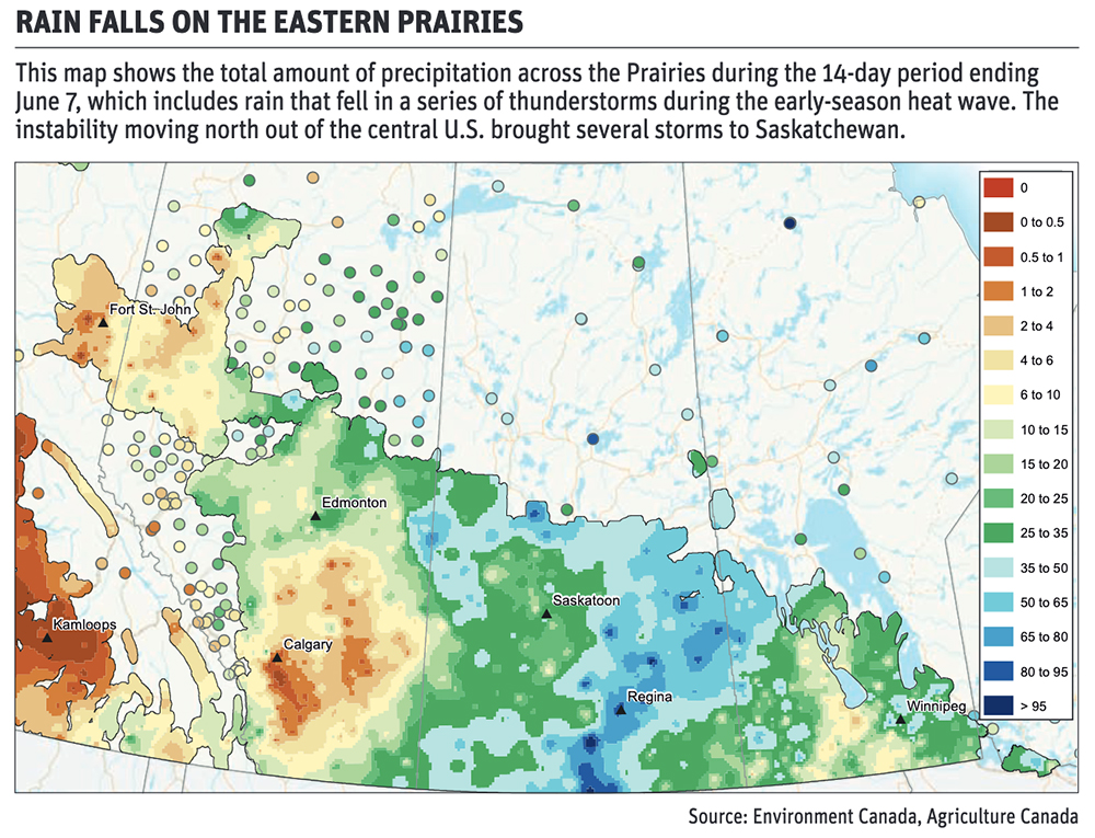
This is what we saw during the recent heat wave. The area of low pressure to the south created areas of instability and convergence that helped kick off thunderstorms.
Usually temperature will not decrease rapidly with height in the middle of an air mass. The wind will usually remain constant with height, and there will probably not be a jet stream overhead.
But we can still have enough heat and humidity for air to rise and thunderstorms to form. Since these storms don’t rotate or vent at the top, they rarely last long. Accumulating air at the top of the storm will eventually fall as a downdraft. This eliminates the updraft, essentially killing the storm. The whole process can take anywhere from 30 minutes to an hour or two.
While these storms are short-lived, they can give brief periods of heavy rain and the odd gust of wind, especially when the downdraft first hits the ground.
Daniel Bezte is a teacher by profession with a BA in geography, specializing in climatology, from the University of Winnipeg. He operates a computerized weather station near Birds Hill Park, Man. Contact him at daniel@bezte.ca.