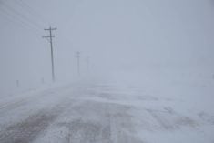
An early spring snowstorm that dumped 50 centimetres of snow on parts of North Dakota last week should cause only a slight increase in water levels on Manitoba’s Red River this spring, say provincial forecasters.
However, peak water levels along the Red will likely exceed 2009 by 0.4 to 0.7 metres, forecasters announced March 25 during the province’s latest flood outlook.
Spring 2009 saw Manitoba’s second worst flood in the last 100 years in terms of water volume.
Water from the Red flooded 800 sq. kilometres of land between Winnipeg and the U.S. border.
Read Also

Canadian Food Inspection Agency red tape changes a first step: agriculture
Farm groups say they’re happy to see action on Canada’s federal regulatory red tape, but there’s still a lot of streamlining left to be done
The widespread flooding in 2009 closed Highway 75, the primary road to the United States, and submerged dozens of gravel roads in the region, forcing farmers to commute to their homes by boat or tractor.
Provincial forecasters were already predicting a flood similar to 2009 before an early spring blizzard hit North Dakota and parts of the Prairies March 22.
The storm walloped most of North Dakota, dumping 10 to 50 cm of snow across the state, said Sam Walker, a National Weather Service meteorologist in Bismarck, N.D.
The blizzard hit the Red River Valley particularly hard, with 48 cm of snow falling on Mayville, N.D., southwest of Grand Forks.
However, forecasters said cooler than normal temperatures in late March have slowed the spring melt, delaying the arrival of North Dakota water in Manitoba.
As well, most homes between Winnipeg and the U.S. border should be safe. Following the 1997 flood, farmhouses and other residences in the Red River Valley were reconstructed on elevated ground or protected by a ring dike.
The Red River is normally the focus of flood preparation in Manitoba, but this year the government is also concerned about flooding in western and central parts of the province.
High soil moisture levels and higher than average precipitation this winter in Saskatchewan, North Dakota and Manitoba have increased the risk of flooding on the Souris and Assiniboine rivers.
The province is reinforcing and raising 70 km of dikes along the Assiniboine between Portage la Prairie and Elie, Man.
As well, Manitoba Water Stewardship has lowered water levels in the Shellmouth Reservoir near Russell, Man., to provide maximum storage space for spring runoff.
———
1997200919501979163,000128,000108,000108,00034.432.530.3
30.3