July saw below average temperatures, August came in with near to slightly above average temperatures and September built on this warming trend with all the main reporting stations coming in well above average temperatures for the month.
Looking at the mean monthly temperatures for the month of September, the warmest actual location was once again Winnipeg, coming in at 15.8 C. This was followed closely by Regina at 15.7 C and then Calgary at 15.6 C.
Comparing the mean monthly temperature to average, the warmest locations were Calgary, coming in 4.6 C above average, and Edmonton coming in second at 4.0 C warmer than average.
Read Also
Alberta cracks down on trucking industry
Alberta transportation industry receives numerous sanctions and suspensions after crackdown investigation resulting from numerous bridge strikes and concerned calls and letters from concerned citizens
The cold spot, when looking at actual mean monthly temperatures, was Peace River with a reading of 13.8 C, whereas the coldest region compared to average was Brandon, coming in at a measly 3.0 C above average, still pretty darn warm.
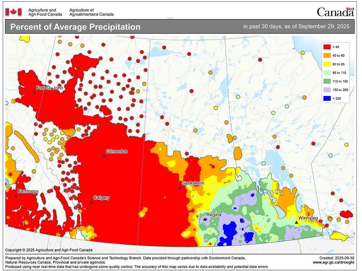
Looking at precipitation, it was extremely dry across the western half of the Prairies with most of Alberta seeing little to no precipitation during September. Precipitation was near to above average across southern Manitoba and parts of southern Saskatchewan, while central regions of Saskatchewan saw below average amounts.
Overall, it was a much warmer than average September, with western regions seeing well below average precipitation and eastern regions seeing near to above average amounts.
Looking back at the forecasts, the winner is the CFS model with its forecast of well above average temperatures and below average precipitation.
Now on to our look at the latest medium-to-long-range forecasts.
Medium and long-range forecasts
As usual, we will start off with the almanacs.
The Old Farmer’s Almanac is calling for near to slightly above average temperatures and precipitation during the last couple of months of fall and into the first month of winter.
The Canadian Farmers Almanac appears to be calling for below average temperatures in October and November along with above average precipitation. It then transitions to near average temperatures and precipitation in December.
Moving on the different weather models, last month’s winner is calling for above average temperatures in October and November with near average temperatures across the eastern Prairies in December with western regions seeing below average temperatures. Precipitation will be below average in October with near average in November and December.
The CanSIPS model is calling for well above average temperatures in October, which then transitions to near average in October and below average in December. Its precipitation forecast is calling for near to below average across all three months.
Looking at NOAA’s prediction, it is calling for the next three months to see near average temperatures and precipitation, except for southern Alberta, which would see above average amounts.
Last is the ECMWF, or European, model. It is calling for above average temperatures in October and November, transitioning to near average in December. Its precipitation forecast is calling for below average amounts in October, transitioning to above average by December.