The Manitoba government is considering building ring dikes and other permanent measures to protect property north of Winnipeg, says the province’s intergovernmental affairs minister.
“We’re going to be talking to municipal leaders today … looking at something equivalent to what happened in the Red River Valley (south of Winnipeg),” Steve Ashton said at a April 13 new conference that announced disaster financial assistance for Manitoba residents forced out of their homes by high water.
Following the disastrous flood of 1997, which forced thousands of people from their homes south of the city, ring dikes were built around communities and homes were built on elevated earthen pads to provide permanent protection from flooding.
Read Also

Stacking Canada up on gene editing livestock
Canada may want to gauge how Argentina and other countries have approached gene editing in livestock and what that has meant for local innovation.
“It’s one of the reasons, by the way, why the impact of the Red River in this flood is far less than it would’ve been pre ’97,” Ashton said.
In an effort to help homeowners this year, disaster financial assistance will help pay for evacuation and the costs associated with flood protection, the province said in a news release.
In a separate release, Manitoba Water Stewardship announced that 10 millimetres of rain over the Easter weekend will lead to a higher than expected crest.
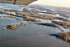
The Red River is now forecast to peak at 1979 levels, the second largest flood in Manitoba’s recorded history.
Although that is news in itself, the real story in Manitoba this spring has been ice jams on the Red north of Winnipeg.
The jams have forced residents in the municipalities of St. Andrews and St. Clements to erect sandbag dikes to protect their property.
On April 12, the release of an ice jam caused a rapid rise in water levels at Breezy Point, an area of cottages and homes north of Selkirk.
The surge flooded several properties and nine people were rescued in the early hours of the morning, Manitoba Water Stewardship said.
The extent of property damage in Breezy Point was not determined as of press time April 13.
However, Ashton estimated the destruction from the flood of 2009 would exceed 2006, when there was $12 million in damage in the Red River Valley.
“We’re well above that already,” he said.
In contrast to damage north of Winnipeg, the ring dikes and other permanent structures south of the city have reduced the need for extensive sandbagging and other emergency measures.
“We’re doing fine, you do what you have to do,” said Sue MacLeod, who runs Glenlea Greenhouses with her husband Rob 20 kilometres south of Winnipeg.
“We’ve been through this enough times that we know what to do and we’re prepared for it.”
MacLeod sounded calm in a brief interview, even though flood water surrounded their property and greenhouses. Their decision to raise the height of earthen dikes this spring is providing peace of mind, she added.
“We probably still have about two and a half feet (0.8 metres),” of protection, added MacLeod, who has greenhouses 40 metres from the river.
Water levels on the dike are expected to rise another 0.3 metres, she said, and will probably crest this weekend.
“We should be OK, unless there is big wave action.”