Records aplenty | Experts disagree on long-term forecast
What was expected to be a cooler-than-normal winter has, so far, seen balmy temperatures across the Prairies, and even rain in some centres.
Through December, temperatures across the Prairies were much warmer than normal.
Already in 2012, Calgary has seen successive days without freezing and, last week, Saskatchewan saw record-setting temperatures across the province, with Maple Creek topping 16 C on Jan. 4. Positive temperatures persisted through the Jan. 7-8 weekend.
“I’m a little gun shy right now given the fact that we said it was going to be a colder than normal winter,” David Phillips, senior climatologist with Environment Canada, said last week during the winter heat wave.
Read Also

August rain welcome, but offered limited relief
Increased precipitation in August aids farmers prior to harvest in southern prairies of Canada.
At the end of November, Environment Canada’s seasonal forecast projected below-normal temperatures for the entire prairie region, showing the effects of La Nina conditions.
That projection has been updated for the three-month period January through February to show cooler-than-normal temperatures in the northern Prairies, but also normal temperatures in wheat-growing areas in the southern and central parts of the provinces and even milder weather in the southern regions along the Souris and Assiniboine rivers.
It’s not uncommon for the province to see warm days in the middle of winter, but what makes this year’s weather stand out is how it’s stayed warm.
“It really has truly been a remarkable winter, but you can’t hold this,” said Phillips. “The bully is winter and the bully is sleeping and it will waken up and come and freeze.”
The warmer autumn and winter can be linked to the positive phase of Arctic oscillation and a weak La Nina, explained Drew Lerner of World Weather Inc.
The positive phase has hung around longer than expected, but Lerner expects the weather pattern to enter its negative phase in the next few weeks, which should send colder air down to the surface.
“It may not be cold all the time and it may not be bitterly cold because there doesn’t seem to be a tremendous amount of bitter cold air in the higher latitudes right now, but we will see colder conditions than what we’ve been seeing.”
Colder temperatures, however, don’t necessarily mean increased precipitation and there hasn’t been a lot of that either. In Manitoba, Winnipeg has seen 27 centimetres of snow through to the end of last week. A normal year has 47 cm.
“It’s like the totally opposite of last year,” said Phillips. “Last year was the perfect storm for flooding. This is the perfect storm for no flooding.”
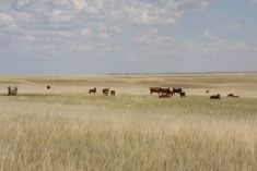
Keith Robertson, chief executive officer of the Saskatchewan Cattlemen’s Association, said conditions through the early part of January were generally favourable for his industry — warmer temperatures are friendlier to livestock — but “moisture is always in the forefront of our minds.”
Relative to drought years, soil moisture isn’t yet a concern, said Bruce Burnett, director of weather and market analysis with the Canadian Wheat Board. The lack of snow cover is an issue for winter cereals, but the region hasn’t seen enough cold to cause damage.
Environment Canada’s projection for January through March shows above-average precipitation for most of the Prairies.
But Lerner said that with a dry bias through the fall and early winter, below-average precipitation can be expected.
“We’ll have a lot of cold air around and it’ll push the jet stream far to the south, so far to the south that we’ll not be involved with the jet stream or the storm track and so we’ll end up missing all the major storms,” he said.
“If everything goes the way I think it will, we will have some snow to melt. It will not be substantial, but it will moisten up the topsoil maybe in the early days of spring a little bit,” he said. “We will have some moisture deficits in the region.”
(With files from Reuters)