At the end of the last issue, I indicated that we would begin our look at the full long-range winter forecast and take a detailed look into what factors might come into play.
There are currently three main factors that could be a driving force behind the type of weather we may see this winter:
- La Nina, which is currently in a weak stage.
- The northern Pacific is experiencing well above average temperatures.
- Early season snow cover across Siberia.
Let’s start by looking at La Nina and how can it impact our winter weather.
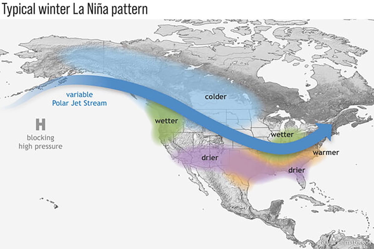
La Nina is the opposite of an El Nino event, and it occurs when there is an increase in the strength of the normal pattern of trade wind circulation.
Read Also

Trump’s tariffs take their toll on U.S. producers
U.S. farmers say Trump’s tariffs have been devastating for growers in that country.
Under normal conditions, these winds move westward, carrying warm surface water to Indonesia and Australia and allowing cooler water to upwell along the South American coast.
When a La Nina event occurs, these trade winds are strengthened, which helps to increase the amount of upwelling, which in turn creates more cooler water along the coast of South and Central America and builds up warmer waters on the western side of the ocean.
These changes in the tropical Pacific are usually accompanied by large changes in the jet stream across the mid-latitudes impacting North America. This shifted jet stream can contribute to large changes in the normal location and strength of storm paths and can result in temperature and precipitation anomalies over North America that can persist for several months.
Like last year, the latest La Nina advisory is predicting the current weak La Nina to continue through early 2026 before transitioning to neutral conditions. Since La Nina is expected to be on the weak side, this would likely result in limited impact on our weather this winter.
The map shows that we often see colder than average temperatures, but if we look back at the last 13 weak La Ninas, six of them saw near to below average temperatures, six were near to above average and one saw above average temperatures over the eastern Prairies with below average temperatures over the West.
So, statistically, this does not help us out that much in predicting this winter’s temperature forecast because it is almost a perfect split between whether a weak La Nina winter will be warmer or colder than average.
When it comes to snowfall, during a usual La Nina winter we will, on average, see above average snowfall over most of Alberta and parts of extreme southern Saskatchewan along with the north-central parts of Saskatchewan. The rest of south-central Saskatchewan along with southern and central Manitoba typically sees near to below average snowfall.
In the next issue we will look at how the current warmer northern Pacific could make a mess out of the typical La Nina weather pattern. We’ll also investigate what impacts an early snowpack in Siberia might have on the upcoming winter.