
I recently tried to explain how I create a forecast so you can do it too.
Here is the Coles notes version:
- Make sure you have a solid basic understanding of the weather; in particular, highs, lows, pressure patterns and how the atmosphere flows at various heights. A good visualization tool can be found at: https://earth.nullschool.net/
- For a longer-range forecast, I use two or three different weather models: Global Forecast System, European Centre for Medium-Range Weather Forecasts, and the Canadian Meteorological Centre. These can be accessed through several different websites but the two I use are: The College of DuPage Nexlab: https://weather.cod.edu/forecast/ and Tropical Tidbits: https://www.tropicaltidbits.com/analysis/models/
- Play with the different types of data available for the different weather models. Start watching them a couple of times a day to see how things change over time.
- Finally, look at what is being forecasted, then look at the weather models and see if you can understand why the forecasters predict what they do.
Read Also

Volunteers help exotic animal farm rebuild
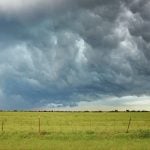
Exotic animal farm loses beloved camel and pony to huge hail storm that gripped the Brooks, Alta. area as a community member starts a fundraiser to help the family recover from the financial and emotional damage.
Eventually, you will reach the point where you see a five-day forecast, check the weather models and then say to yourself, “I don’t think day four and five are correct, I think it is going to be …” When you get to this point, you are forecasting.
The nice thing about building an understanding of medium-range weather models is that you get an idea of what the weather will be like seven to 14 days down the road. Most professional forecasts only go out five to seven days and a few go out to 10 days.
For more immediate forecasts, we switch to the short-range models. These run every one to three hours and they also have much higher resolution. It requires a lot of computing power, so the forecast coverage is a much smaller area.
The first of these models is the High-Resolution Rapid Refresh (HRRR) model. According to the National Oceanic and Atmospheric Administration (NOAA) website, it is a real-time, three-kilometre resolution, hourly updated, cloud-resolving, convection-allowing atmospheric model, initialized by three km grids with three km radar assimilation.
Radar data is assimilated in the HRRR every 15 minutes over a one hour period, adding further detail to that provided by hourly data assimilation from the three km radar-enhanced rapid refresh. Every six hours it generates a 48-hour forecast and each intervening hour it generates an 18-hour forecast.
Since this model is U.S.-based and runs every hour at a high resolution, it covers all the U.S. but only shows the southern third of the Canadian Prairies.
The second model is the RAP, which is NOAA’s Rapid Refresh model that runs every three hours with alternating forecast lengths of 21 and 51 hours.
With these two models, I mostly look to see if I agree with what they say. I compare them, looking primarily at precipitation, total precipitation, temperature and wind speed forecast maps. Since this is short-range forecasting, I also compare the model forecasts to what is actually occurring by looking at radar and satellite images.
A word of caution: do not override what these short-range models forecast over a six-hour period, especially if the predicted weather is bad or dangerous. These models are complex and usually do a pretty good job. Our job as hobby forecasters is to make little tweaks to the forecast that make us look like brilliant weather nerds to all our friends.