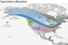
The latest world monthly temperature rankings have come out for May. Not surprisingly, it turned out to be one of the warmest Mays on record, rated third warmest by both NASA and the National Oceanic and Atmospheric Administration.
Both North and South America had their warmest Mays on record. Canada saw its warmest May since 1940, and it was the second driest. Forest fires have burned their fourth highest acreage since 1983, with the two worst forest fire months still to come.
There were 77 all-time heat records for May globally, with no all-time cold records set.
Read Also

VIDEO: Claas Axion 9.450 tractor wins ‘Tractor of the Year’ at Agritechnica 2025
On opening day of Agritechnica 2025, Claas’ Axion 9.450 Terra Trac tractor was awarded ‘Tractor of the Year’ for 2026 in the HighPower category.
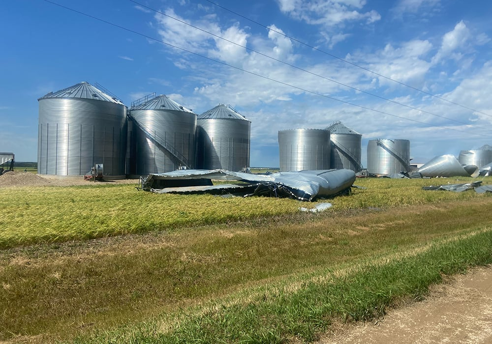
This week’s severe summer weather topic is straight-line winds.
While we all know about tornadoes, most of us haven’t experienced one. However, I can pretty much guarantee that if you live on the Prairies, you will experience a thunderstorm that produces very strong straight-line winds.
Sometimes these winds are so strong and devastating that their damage is attributed to a tornado, and the only way to determine the true cause is to look at the pattern of damage.
In tornadoes, damage will be more random, with trees and objects broken and thrown in different directions due to swirling air. With straight-line winds, nearly all the damage is in one direction.
Nearly all straight-line winds occur near the leading edge of a thunderstorm. Thunderstorms have areas of updrafts and downdrafts. With updrafts, air moves upward due to either being warmer than the air around it or being forced upward as horizontally moving air is deflected by something like a cold front.
Downdrafts are more difficult to understand. When a thunderstorm moves in, we often get that first big blast of wind that announces its arrival as clouds open up and rain begins. There are two main causes for these winds.
First, all the air rising to the top of the storm has to go somewhere. In a strong storm, an overhead jet stream will vent away this air but this is only partially successful. Eventually the buildup of air becomes so big that it begins to fall back toward the ground.
This falling air combines with the rain that is also falling. The rain pushes on the air around it. This downward-moving air hits the ground and then has to flow somewhere. But falling rain acts like a wall, preventing much of this air from flowing back into the storm.
Instead, most of it is pushed in front of the storm. These downbursts can be short-lived or they can continue for long distances as the thunderstorm travels.
The long-lived events are known as derechos. Peak wind speeds in these downbursts can routinely hit over 100 km-h, with some gusts peaking at over 200 km-h.
The worst derecho on record in Canada occurred last May in southern Ontario and Quebec. Wind speeds were recorded as high as 190 km-h along a path that extended for nearly 1,000 kilometres and took nearly nine hours to play out. Damages exceeded $750 million, making it Canada’s sixth most costly weather disaster on record. Sadly 12 people were killed, mostly by falling trees.
We also often get very strong winds in the middle of the storm. One reason is the jet stream or strong upper-level winds. Strong thunderstorms often need strong upper-level winds to help vent all the rising air. Occasionally, these strong winds get caught in a strong downdraft and are deflected toward the surface.
If they make it all the way down, they spread out and can flow in several different directions, depending on the angle from which they came. This is why this type of straight-line wind can be confused with tornadoes because these winds can often seem more chaotic than the winds that preceded the thunderstorm.
Daniel Bezte is a teacher by profession with a BA in geography, specializing in climatology, from the University of Winnipeg. He operates a computerized weather station near Birds Hill Park, Man. Contact him at daniel@bezte.ca.